23 New Fragments Travel to Stanford
|
|
The Idea
Recent improvements in laser rangefinder technology, together with algorithms
for combining multiple range and color images, allow scientists to digitize reliably and
accurately the external shape and surface characteristics of many
physical objects. Examples include machine parts, design models, toys, and
artistic and cultural artifacts. As an application of this technology, a
team of 30 faculty, staff, and students from Stanford University and the
University of Washington spent the 1998-99 academic year in Italy scanning the
sculptures and architecture of Michelangelo (refer to Levoy 2000
or The Michelangelo
Project for more information). During this year abroad, we became involved in several
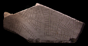
side projects. One of these was the digitization of
the Forma Urbis Romae.
|
The idea of using laser scanners and computer graphics to visualize the
fragments of the Forma Urbis was first suggested to us in January of 1997 by
Susanna Le Pera of the Archeological Superintendency of Rome.
The idea of using computer algorithms to piece the map together was our own.
We initially thought that it would be a simple matter of searching among digital
photographs of the fragments for matches between their border shapes or the
incised designs on their top surfaces. Unfortunately, these top surfaces are
often eroded, reducing the effectiveness of such an approach. Moreover, considering the fact that
scholars have spent the last 500 years searching for matches among these incised
designs, it seemed unlikely that we would find many more. On the other hand, the
fragments are several inches thick, and fragments that do fit together usually
mate intimately across at least a portion of the interface surface between them.
The idea was to develop compact signatures for these border
surfaces and to search among the signatures for matches.
The proposed approach is a classic N2 search problem.
Since features on the
scale of 1 mm can make or break a potential match, and since there are over a
thousand fragments, the search space is large. However, there are several
features of the fragments that can be used to speed it up. For example, the
slabs comprising the map vary in thickness over a range of several inches, so
they can be sorted by thickness; then matches can be sought by
looking at close neighbors in the sorted list. Other useful features include
marble veining, which is usually highly directional and therefore constrains
the space of possible matches, the presence of straight borders and clamp
holes, which denote fragments lying at the edges of slabs, and of course the
continuity between fragments of the incisions themselves.
In order to test these ideas, we needed to scan and build 3D geometric and
photographic models of every fragment of the map. This was not an easy task.
(back to top)
Getting Started
In March of 1999, we returned to the Archeological Superintendency with a proposal
to digitize the 1,163 fragments of the map (23 more fragments were discovered after the completion
of the scanning project in Rome). Although the superintendent,
Eugenio La Rocca, was supportive, there was understandable hesitation from the curators -
the map is a priceless artifact, and the fragments are heavy, fragile, and numerous.
Eventually, however, they acquiesced, and two of the curators, Anna Mura Somella and Laura Ferrea,
became enthusiastic and valued collaborators of the Project. In the space of a few weeks in April,
1999, we obtained the necessary permissions, found funding (some of which was provided
by the City of Rome), assembled a team
(which included Laura Ferrea), rented an apartment in Rome, and moved the group and
several tons of computers and scanners from Florence to Rome.

|
|
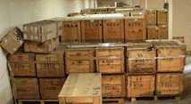
Until recently, the fragments of the Forma Urbis were housed in the Museum of
the City of Rome (Museo di Roma) in Palazzo Braschi, a few steps from Piazza
Navona. When that museum was closed for restoration, the fragments were packed into crates and
moved to the basement of the Museum of Roman Civilization,
(Museo della Civilt�
Romana), a vast edifice built by Benito Mussolini in the 1930's in the
Roman suburb of EUR (Exposizione
Universale di Roma).
|
|
|
When we visited the museum in EUR to plan the scanning project, the
museum director, with officials from the archaeological office in attendance,
brought us to the basement and directed our attention to a vast mountain of
crates. Sensing our confusion and terror, the guide from the archaeological
office explained with some amusement that these crates represented the
entire contents of the Antiquarium Comunale - the fragments of the Forma Urbis occupied
"only" 20 of them.
|
|
|
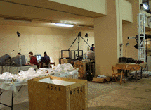
This basement gallery provided a spacious room
in which to set up a temporary computer graphics laboratory. To scan the fragments we used
two Cyberware laser-stripe triangulation scanners. One was a custom design,
originally intended for scanning the statues of Michelangelo, which was adapted
for use in this project. The other was a Model 15, a relatively inexpensive
desktop scanner, which we had
shipped from the United States so that we could scan two fragments at the same
time, doubling the throughput. Both devices had an X-Y sample spacing of 0.25 mm and a
Z-resolution of 50 microns. For acquiring color data we used a
Sony DKC-ST5 programmable 3-CCD digital still camera. It had a nominal
resolution of 1030 x 1300 pixels, which was set up to provide a resolution of
0.25 mm (100 dpi) on the fragment surfaces.
|
(back to top)
Scanning the Fragments in Rome
So the scanning project began. Attrition had pared the team from
22 people down to only 6,
and the budget (and people's spirits) were nearly exhausted. Moreover, time was short: we had only
four weeks left before the customs carnets on the scanners and
computers expired, at which time they would have to be shipped back to the United
States. To scan the 1,163 fragments of the Forma Urbis in such a short time, we instituted round-the-clock
scanning: 24 hours a day, 7 days a week, using the two laser scanners
and the photographic camera stand. The team kept up this pace for 25 days, sleeping
in shifts.
|
|
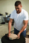
Although most fragments of the Forma Urbis are small, some are large and weigh
several hundred pounds, so the Rome team included two helpers whose job it was to move the fragments
from the crates and lower
them gently onto a motorized rotary
table for scanning.
|
|
|
One of the smaller, unidentified, fragments is here in the process of being
scanned. A laser-stripe scanner digitizes an object by sweeping it with a plane of laser
light, imaging the resulting stripe as it moves across the object surface, and
analyzing the shape of the stripe 30 times per second. Regardless of
the fragment shape, many scans were required to completely cover its surface.
To permit these scans to be aligned, each
surface point was scanned several times to create overlaps. This redundancy also
allowed us to downweight oblique views, which yield poor data in all laser
triangulation systems and particularly poor data when scanning marble, due to
subsurface scattering.
|
|
|
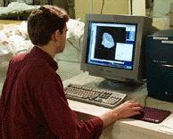
Sitting at the Silicon Graphics Octane, Stanford Ph.D. student David Koller examines the
computer model of a newly scanned fragment. Although we attempted to
automate the scanning process as much as possible, fragments had to be moved by
hand several times during scanning, forcing the team members to perform interactive alignment
of the resulting scans. This step was followed by automatic pairwise alignment of scans using
a modified iterated-closest-points (ICP) algorithm (Besl and McKay 1992),
and finally by a
global relaxation procedure designed to minimize alignment errors across the entire fragment
(Pulli 1999). Once aligned, the scans
were combined using a volumetric algorithm. At some point (small)
holes will be filled using space carving (Curless 1996). The final result will be a (nearly) watertight,
high-detail (0.29mm), triangle mesh representing each fragment.
|
|
|
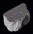
At left is a rendering of the raw 3D data for a fragment. The fragment is 5
inches across, small enough to be scanned using a Cyberware Model 15. In
order to see the entire surface, linear scans were taken from 18 different
directions. Even so, at least one hole is evident (blue circle). It is less
than a millimeter across, so it will be filled later by using an automatic
hole-filling algorithm. The 18 scans have been aligned with each other using
the ICP algorithm described above. The residual error, about 0.25mm, is visible
as interpenetrating surfaces (yellow circle). The volumetric range image merging
software (vrip) will replace these interpenetrating surfaces with a single surface at an
average location.
|
|
|
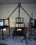
To reduce the time required to scan each fragment, we did not use the color
camera built into the Cyberware scanner. Instead, we assembled the
separate color digitization station seen here, which operated in parallel with the
Cyberware scanner. The spotlights surrounding the table
have been arranged to cast a raking light across the fragments, a lighting
configuration frequently employed when photographing incised stone artefacts.
The camera we used was a Sony DKC-ST5 programmable 3-CCD digital still camera
with a nominal resolution of 1030 x 1300 pixels. The camera was set up to provide a
resolution of 0.25 mm (100 dpi) on the fragment surface. This resolution is sufficient
to create a 1:1 museum-quality, photographic reproduction of the entire map.
After each photograph was taken, it was dewarped to correct for camera lens distortion.
To calibrate a camera, we separately photographed a planar target, located a number
of feature points on it, and used these to calculate the camera's intrinsic parameters.
The model included two radial and two tangential distortion terms, off-center perspective
projection, and a possibly non-uniform (in X and Y) scale
(Heikkila 1997). Given the
high resolution at which we were photographing, large fragments had to be photographed
in sections and mosaiced together. For this purpose, we mostly used Image Assembler,
a commercial image mosaicing package from Panavue, Inc.
|
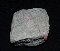
23 New Fragments Travel to Stanford
In 1999, 30 more fragments from the Severan marble plan were discovered in the Italian
excavations of the Templum Pacis. Some were joined during conservation, making a total
of 23 fragments. In an unprecedented and very generous move, prompted by
Laura Ferrea, the Sovraintendenza offered to bring these new fragments to Stanford to
be scanned there. In May of 2001, Ferrea personally oversaw the transfer of the
valuable marble pieces from Rome to Stanford and the scanning of each fragment
by our team in the graphics lab of the Computer Science Department.
- Besl and McKay 1992
- Besl, P., McKay, N., A Method for Registration of 3-D Shapes, IEEE Trans.
PAMI, Vol. 14, No. 2, February, 1992, pp. 239-256.
- Curless 1996
- Curless, B., Levoy, M., A Volumetric Method for Building Complex Models from Range Images,
Proc. SIGGRAPH '96, ACM, 1996, pp. 303-312.
- Heikkila 1997
- Heikkila, J., Silven, O. A four-step camera calibration procedure
with implicit image correction, Proc. CVPR '97, IEEE, 1997, pp. 1106-1112.
- Levoy et al. 2000
- Levoy, M., et. al., The Digital Michelangelo Project: 3D Scanning of Large Statues,
Proc. SIGGRAPH 2000, ACM, 2000, pp. 131-144.
- Pulli 1996
- Pulli, K., Multiview registration for large data sets, Proc. 2nd Int'l Conf. on
3-D Digital Imaging and Modeling, IEEE, 1999, pp. 160-168.
(back to top)
© The Stanford Digital Forma Urbis Romae Project