Past Scholarship
The following essays summarize and add to the work published in
PM 1960,
AG 1980, and Reynolds 1996.
Click here for information on how to cite from this text.
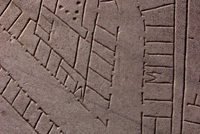
Detail of fragment 10g
|
|
INTRODUCTION TO THE FORMA URBIS ROMAE
Carved in the beginning of the 3rd cent. CE, the large marble plan of Rome (variously referred to
as the Severan Marble Plan, the Forma Urbis Romae [FUR], the Pianta Marmorea [PM], or as the
Forma Urbis Marmorea [FUM]) depicted in astounding detail the ground plan of all architectural
features in the ancient city. The map (measuring ca. 18.10 x 13 meters or ca. 60 x 43 feet) was incised onto marble
slabs that hung on a wall of a grand room (aula) in the Templum Pacis in Rome. Time, and the need for
marble as a building material, gradually destroyed the Plan. Today,
only 1,186 pieces, or 10-15%, of this gargantuan city map exist.
|
Centuries of research
by mainly Italian scholars have produced impressive results in the endeavor to reconstruct the
map and understand its setting and its date. Nevertheless, numerous fragments are still unidentified and
many questions remain unanswered. Some of the major problems with the Plan will be addressed
below, while questions regarding individual pieces of the map are discussed in the
entries for the relevant fragments.
There are no references to the Marble Plan in the ancient sources.
This means it can only be dated by an examination of its setting and
from the evidence on the map itself. The fundamental study is by G. Gatti, PM
1960, pp. 213-218.
Textual sources tell of a disastrous fire in the
Templum Pacis in 192 CE (Cass. Dio 72.24.1-2). Various pieces of evidence suggest that
the building was repaired under Septimius Severus (193-211 CE).
According to a close study done by L. Cozza, much of the brickwork on the wall on which the Plan was mounted
is Severan (PM
1960, p. 177). This date agrees with the absence of any post-Severan monuments on
the surviving fragments; the letters inscribed on the Plan
also comfortably fit this date.
Two pieces of evidence carved onto the Plan itself narrow down the
date of its creation to the years between 203 and 211 CE. First, the
Septizodium, visible on fragments 8a
and 8bde, provides us
with a terminus post quem. This
monument was built by Septimius Severus in 203 CE (CIL VI, 1032); its
presence indicates that the Plan was carved after that date. Second,
an inscription on fragment 5abcd provides a terminus ante quem. This inscription
mentions Septimius Severus and his son Aurelius Antoninus
(Caracalla) as co-emperors. This was true between 198 CE, when
Caracalla was created Augustus to rule alongside his father, and Feb.
4, 211 CE, when Septimius died.
The commonly favored date of the Plan's creation is therefore 203-211
CE. Perhaps significantly, the inscription on fragment 5a does not
mention Septimius' younger son Geta, made Augustus in 209 and
assassinated by his brother in 212. This may mean that the Plan was
carved before 209 CE, but there may also be other explanations for
his absence. G. Carettoni's suggestion that the Plan was created
between 205-208 CE, when the office of urban prefect was
reorganized by Severus, has not met with
wide acceptance (PM
1960, pp. 215-217).
There is an unresolved controversy about whether one or more monumental plans of Rome existed before the
Severan map, and what the relationship of the Severan map might have been to any predecessors. For an introduction
to the issues, see Reynolds 1996, pp. 53-59, and
Steinby 1989, pp. 32-33.
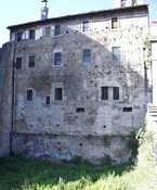
Wall of the aula today
|
|
The creation of the Forma Urbis Romae probably followed shortly after the repair of the Templum Pacis
under Septimius
Severus. Large patches of brickwork, shown by scholars to be
Severan repairs to the originally Flavian building, are still
visible on the
wall of the aula where the Plan once hung (see photo at left). Once repaired, the wall was
faced with heavy marble
slabs that were held in place with clamps. Inconsistencies in slab thickness were then eliminated by smoothing the
slab edges. The incisions were carved on top of these smoothed areas, proving that the Plan was carved with the slabs already
already mounted on the wall. The incised map covered 150 marble slabs, together measuring
ca. 18.10 x 13 meters (ca. 60 x 43 feet). The 150 slabs were arranged
in 11 rows. The bottom 8 rows alternated between vertical and horizontal slabs; the top 3 rows of slabs
were placed horizontally. For a digital map showing the positions of the slabs, click here. Below the map, the wall was faced with (from the ground up)
a socle,
a cornice, a tall orthostate, another cornice, and finally two rows of plain marble facing.
(PM 1960, pp. 177-195)
The Forma Urbis Romae depicted the ground plan of every building and monument in the imperial city at a scale of
1:240. Following standard practice, the map was oriented with southeast at the top.
|
The carvers generally used single lines to represent the walls of buildings. In a few cases,
including temples (see for example
fr. 18bc), the Porticus Aemilia
(fr. 24b),
and the Septizodium (fr. 7a), the
walls and column bases are rendered in outline and sometimes recessed as well. These outlined areas were filled
with red paint
for emphasis. Doorways are usually shown as a break in the line of a wall; arcades are shown by
dashed lines; colonnades are represented as lines of dots; indoor staircases
are usually represented by a V or a triangle; outdoor stairways are typically indicated by a series of short
perpendicular lines between two
long parallel lines.
An interesting aspect of the map is that no geographical or political boundaries appear; only architecture was incised.
The Tiber River, for example, appears only as a blank space between the rows of warehouses and buildings
on its opposite banks. We do not know if the Tiber was emphasized with red or blue paint. Similarly,
the sacred boundary of Rome, the
Pomerium, is
missing from the Plan.
(PM 1960, pp. 199-210, 221-233)
(back to top)
An almost greater puzzle than the Forma Urbis itself is the question of its function.
There is no comparative material, literature or inscriptions from antiquity that might
shed some light on this problem, nor has the function of the room in the Templum Pacis where
the Plan hung, been clearly understood.
Most scholars believe that the aula in which the map hung was the office of the
urban prefect, and that the map had a utilitarian purpose,
functioning either as a locator map or as a cadastral map (recording land ownership) of Rome. They
base their arguments on the incredible detail and accuracy of the map, which must have been the result
of real land surveys, and on the scale of 1:240 which is the common scale used in Roman map making.
David Reynolds (1997, pp. 115-123), however, has demonstrated that the Plan could not
have functioned as a locator map. It was, first of all, too large to be consulted. Someone standing on the floor
in front of it would not have been able to make out the
details at top, more than 40 feet up the wall. It would furthermore have been useless as such because only a
small percentage of
its features were labeled with inscriptions to guide the viewer. It finally lacked
measurement notations that are common in other known Roman maps. The theory that the map was of cadastral
use must
also be discarded, according to Reynolds. Unlike the few known Roman cadastral maps of stone, the Severan
plan delineated
walls with single lines (as opposed to double outlines) and it lacked ownership annotations. Furthermore,
despite the astonishing accuracy of the Plan, there are sloppy mistakes in the
carving of some of the most prominent public buildings on the map, mistakes that would not have been
acceptable if the Plan indeed served the purpose of ownership record, a function for which precision would
have been important.
Reynolds convincingly argues (1997, pp. 124-134) that the Severan
Marble Plan, rather than serving a utilitarian purpose, was a decorative showpiece. He suggests that there were two Formae Urbis Romae, and that
both were kept
in the aula of the Templum Pacis, which he agrees functioned as the cadastral record office in Rome.
According to Reynolds, one plan was the
official cadastral record of Rome. This map would have consisted of sheets of papyrus on which the
precise information from a detailed land survey of Rome was recorded on a scale of 1:240, complete with
annotations of landownership and measurements. The scrolls would have been easily accessible, readable, and
updatable. The other Forma Urbis Romae was the marble plan, whose sole purpose was to decorate a wall in
the room that was devoted to the storage and use of the real cadastral records. The marble plan was created
by copying the information from the offical records onto the marble slabs.
Reynold's thesis clarifies why the Plan adhered to some map making conventions but dispensed with
others. The Plan was detailed, accurate, and of a common scale because it was copied from cadastral records
that were based on precise surveys of
the city of Rome. However, because the map was decorative only, and would not be consulted for
detailed and accurate information, carving mistakes were allowed
to stand, and measurements and annotations were left out because such information was unneccessary. Such detailed
script would
have been unreadable from a distance
anyways, and it would have made the delicate web of carving seem complicated and cramped.
Only a few
of the major public monuments were made to stand out with with large inscriptions and doubly outlined walls.
These perhaps served as orienting indicators for anybody trying to single out, from a distance,
well-known features on the large marble map.
(back to top)
The following summarizes the major events in the history of the Severan Marble Plan from its creation
until today. The information for the years until 1956 is drawn from PM 1960,
pp. 25-31, and AG
1980, pp. 21-24. Information about the more recent history of the fragments has kindly been provided
by Dott. Laura Ferrea, Curator of the Capitoline Museums.
203-211 CE
151 marble slabs are mounted onto a wall of a large room (aula) inside the Templum Pacis in Rome.
Onto this wall of slabs is carved a detailed map of the imperial city of Rome. The incised lines
are filled with red paint so
as to stand out against the white background.
Early 5th century
The Plan suffers its first major damage when a passageway is punched through the wall behind it.
The large, circular hole destroys the area on the Plan that depicted key spaces such as
the Roman forum, the Velia, and the Palatine Hill.
c. 530
The Church of Saints Cosmas and Damian is founded in an adjacent room of the Templum Pacis.
The wall of the
aula on which the Plan hangs becomes the backwall of the new church.
Late Medieval Period
The Templum Pacis, together with the aula of the Marble Plan, is abandoned and gradually
deteriorates.
Many of the marble slabs are robbed for reuse as building material or for the production of
lime. The rest gradually fall
from the wall and are with time buried at its foot.
1562
Many of the marble fragments are discovered in what by now has become a garden behind
the Church of Saints Cosmas and Damian.
The pieces pass into the hands of the Farnese family and are moved to the Farnese palace. The
discovery unleashes a storm of antiquarian interest in the Plan whose existence, until then,
was unknown (see Past Scholarship, below).
c. 1600
Interest in the fragments gradually fades, especially following the death of the curator of
the Farnese collections, F. Orsini. Many of the fragments are lost to scholars when they are
used in the construction of the Farnese family's "Secret Garden" between the Via Giulia and
the Tiber.
1741-1742
The ownership of the Marble Plan is transferred to the people of Rome and the fragments are moved to
the Capitoline Museum. Here, a major project to assemble and exhibit the fragments is undertaken by museum
curator Pietro Forrier with the help of Giovanni Battista Nolli, soon to be famous for his own map
of Rome. The fragments are
exhibited in wooden frames along the main staircase to the museum.
To make the pieces fit into the wooden frames, protruding
areas that have no incisions are sawn off. This happens to fragments 25a, 27c, 44e, 89,
24A, 126, 317, 426, 471, 496ab, 501, 586ab, 602, 619a, 633. With the help of
earlier drawings, marble copies of lost pieces are created and made easily distinguishable
with a star (see for example fr.
18bc). Confusion reigns as some of the lost fragments reappear
(often broken into even smaller pieces) and are exhibited alongside their marble copies.
1813
Fragment 38, depicting the Baths of Agrippa, is discovered in the excavations of the Roman Forum,
near the Column of Phocas.
1867
Fragment 11a, depicting the Porticus Liviae, is discovered during the excavation of a small
area within the aula of the Templum Pacis.
1882
Fragment 18a, depicting
part of the Temple of Castor, is found near this very temple in the
Roman Forum.
1884
Fragment 36b, of the Temple of Matidia, is discovered in the Roman Forum.
1888
During the summer, construction of the Tiber embankment near the Fountain of the Mask
necessitates the demolition of one of the walls that used to enclose the
"Secret Garden" of
the Farnese family. In it
are discovered 6 fragments of the Plan. The subsequent search of the area brings to light
altogether 186 fragments that had been lost since 1600. In the Roman Forum, fragment 011c is
discovered close to the Temple of Antoninus and Faustina, very near the aula of the
Templum Pacis.
1891
In the new excavations of the aula, 25 small fragments are recovered.
1899
The complete demolition of the "Secret Garden" by the Tiber leads to the rediscovery of
451 more pieces of the Plan.
1902
Another 14 fragments appear during work on the walls of the Farnese palace.
1903
The year of the Capitoline Reconstruction of the Plan.
The identified fragments
are mounted onto a large map of Rome, designed by R. Lanciani, and exhibited outside
on a wall in the garden of the Capitoline Museums (Palazzo dei Conservatori).
1924
Having suffered damage from their exposed location in the garden of the Capitoline
Museums, the marble pieces are removed and replaced by casts. All
fragments, including the smaller, unidentified, and blank pieces, are moved to
the storerooms of the Antiquarium on the Caelian Hill.
1924All marble pieces are exhibited in a room in the Caelian Antiquarian: Fragments
from areas considered most important are clamped onto wooden boards on top of graphic
reproductions of topographical lines and inscriptions. Large, isolated fragments are placed
nearby while the smaller pieces are stacked on two great racks.
1931-38
Three small fragments, 330,
421ab, and perhaps 457, are discovered in the excavations of the aula.
1939
The construction of a railroad tunnel underneath the Caelian Antiquarium threatens the stability
of the room in which the fragments of the Plan are kept. They are moved back to the Capitoline
Museums.
1950
Fragment 350ab is discovered in the excavation of the Basilica Aemilia in the Roman Forum.
1955
All fragments are moved to the Braschi palace.
1956
Four additional fragments are discovered in the area of the aula: frs. 709ab, 710, 711a,
and 711b.
1998
The marble fragments are moved from the Braschi palace in the center of Rome to the Museum of
Roman Civilization (Museo della Civiltà Romana) in the Roman suburb of EUR (Exposizione
Universale di Roma) where they are kept in crates in
the storeroom.
1999
During new excavations in the central part of the Templum Pacis, 30 new pieces are discovered.
Some are joined immediately, making a total of new 23 fragments. For a summary of this excavation, click
here.
June 2001 - Jan. 2002
Fragments 13a-o and 8b-f (Colosseum and the Ludus Magnus) are on display in the Colosseum as
part of the exhibition "Sangue e arena".
Sept. 2001 - Feb. 2002
Fragments 11e-i, representing part of the area of the Viminal, are on display
in the Royal Palace in Milan as part of an exhibition on geografical representations of the world
from antiquity until today, called "Segni e sogni della terra. Il disegno del
mondo dal mito di Atlante alla geografia delle reti."
2001
A new fragment belonging to the Severan Marble Plan is discovered during the construction of a subterranean passageway along the Via delle Botteghe Oscure, destined to connect to the underground path near the Museo della Crypta Balbi (see Manacorda 2002).
(back to top)
The following is an account of the major developments in the scholarship on the Forma Urbis Romae.
The information up until 1980 is taken from PM 1960,
pp. 25-31, and AG 1980, pp. 21-24. Information since 1980 has
been compiled from scholarly articles (see the Bibliography for more
information) and with the help of Laura Ferrea.
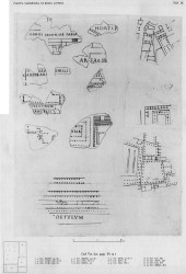
Renaissance drawings of the fragments from PM 1960,
pl. 9
For a larger view of the same plate, click here.
|
|
1562 The discovery of marble fragments stirs great excitement in the scholarly
community, as these appear to be the remnants of a great Roman monument, hitherto unknown. The architect
A. Dosio and the curator of the Farnese collections, O. Panvinio, are
the first to analyze the fragments. Dosio may have made the first inked drawings
of the major pieces, today kept in the Vatican (see Cod. Vat. Lat. 3439).
The image to the left shows some of these inked drawings as published in plate 9 from PM 1960.
1570-80 The inked drawings (by Dosio?) are included in the documentation on the fragments
produced by F. Orsini, now the curator of the Farnese collections.
1673 Embarking upon a project to publish the marble fragments for the first time,
G. Bellori
finds the pieces
in a deplorable state of preservation in
the basement of the Farnese palace and discovers that many are missing. (They had been used as
building material in the construction of the "Secret Garden" between the Farnese palace and the Tiber).
Bellori therefore works partially from the drawings published by Orsini and partially from the
still existing fragments. As he unwittingly copies fragments already drawn, duplications occur in
the resulting publication, Fragmenta vestigii veteris Romae ex lapidibus Farnesianis
nunc primum in lucem edita cum notis (Rome).
1756 G.B.Piranesi draws and publishes the major fragments in the first volume of his
Antichità Romane (Rome), plates. 2-7.
1764 Bellori's earlier publication is revised to include minor and formerly "lost"
fragments and is published as Ichnographia veteris Romae XX tabulis comprehensa...accesserunt aliae VI
tabuale ineditae cum notis (Rome).
|
1825-50 L. Canina is the first scholar to use the
fragments as an archaeological tool to identify monuments of ancient Rome. He publishes
several topographical monographs that, for the first time, focus on individual
fragments and the ancient monuments depicted on them, and he draws the first topographical map of ancient
Rome to incorporate drawings of fragments from the marble plan. Canina's work sparks an interest in
the topographical value of the marble fragments that lives on in Italian scholarship on the Marble
Plan to this day.
1866-73 H. Jordan confronts the overwhelming task of recording a confused mass of material that
by now includes not only the existing pieces, but fragments that have been lost and found, often in
incomplete bits, marble copies of formerly lost pieces that by now often do not match the originals,
marble copies of those fragments that are still lost, and drawings of existing and lost pieces. Among
the scholars who collaborate with Jordan on this project is Rodolfo Lanciani, an Italian archaeologist
who will later become renowned for his extensive excavations in Rome and for his publications on
the archaeology of Rome. Jordan's resulting publication Forma Urbis Romae Regionum XIIII
(Berlin 1874) represents his valiant attempt to organize the fragments, with color-coded drawings
that differentiate between existing and lost (but known through marble copy) and lost (but known
through Renaissance drawings) fragments. For more detail, refer to the
Bibliography.
1899 The discovery of more than 600 new fragments since Jordan's publication has rendered
his work incomplete. Lanciani publishes a brief report in the Bullettino della Commissione Archeologica
Comunale in which he recounts the excavation history
of the Plan and includes photographs of 29 of the newly found, incised fragments.
1960 More than 30 years of careful research on the Marble Plan by
G.F. Carettoni, A.M. Colini, L. Cozza, and G. Gatti,
produce the monumental 2-volume
edition La Pianta Marmorea di Roma Antica (Rome). In addition to detailed essays on the history,
date, function, setting, and technique of the Plan, the publication includes black
and white photographs, descriptions, and interpretations of all incised fragments. For more information,
see PM 1960 on
the Bibliography page.
1980 E. Rodríguez-Almeida publishes his invaluable
update of post-1960 research on the Plan in Forma Urbis Marmorea. Aggiornamento Generale 1980
(Rome 1981). Refer to AG 1980 on the
Bibliography page to see a more detailed annotation.
1980-2003 The publications by Carettoni et al. (PM 1960) and by Rodríguez-Almeida (AG 1980) make close
study of the individual fragments easier. The many articles published in this period remain
topographically oriented and continue to focus on identifying and locating the fragments. Refer to the
Bibliography page or to the database entry for the
individual fragments for more information about these articles.
2003-4 The Stanford Digital Forma Urbis Romae Project makes its database of the fragments
available worldwide on the Internet. The database is the first complete publication of the Severan
Marble Plan, as it
presents digital color photographs and 3D models of all existing fragments, including, for the first time ever,
the blank ones -- 1,186 pieces in all. The database also includes detailed images of 87 lost fragments,
known only from Renaissance drawings. To access this database, click here.
2006 Publication of the 23 new fragments discovered in the excavations of the Templum Pacis in 1999.
(back to top)
Copyright © The Stanford Digital Forma Urbis Romae Project