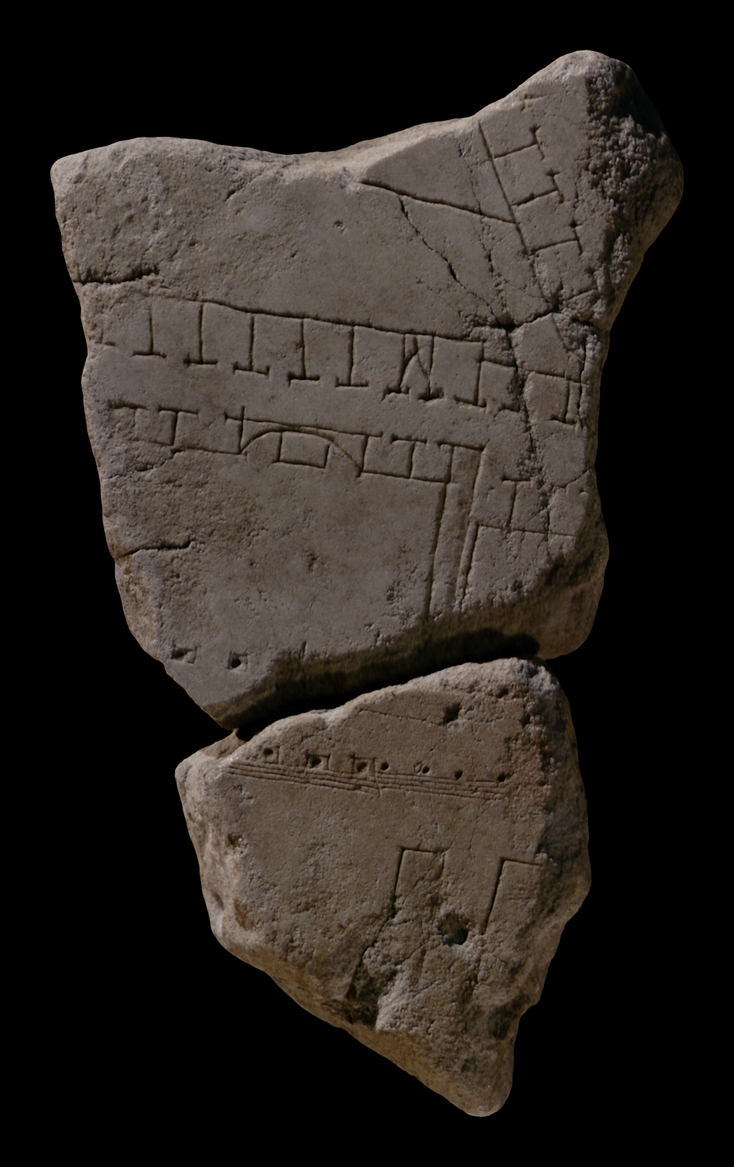
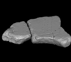
| Description A horizontal row of multi-storeyed tabernae crosses the fragment at top, with the shops facing downwards. (N.B. The singular staircase is missing in the drawing in AG 1980, pl. 12.) Just before reaching the right fragment edge, the back wall of the row moves forward and decreases the depth of the shops on the right. A second row of shops approaches the horizontal row at an angle from above but stops short just before meeting it. The large space thus framed at the bottom and on the right by these rows seems to be open to the sky. The horizontal line that divides it perhaps represents a low wall. A street separates the horizontal row of tabernae from a large hall with a central apse in the back wall. The apse holds what seems to be a statue base. Smaller shops back onto the rear wall of the apsed room and onto a large room to its right, from which it is separated by a thick, recessed wall. In front, the hall is lined with dots within small squares. Elsewhere on the plan, these seem to represent columns on plinths (see front of Porticus Octaviae in fr. 31u. The hall opens onto a large, sunken courtyard, surrounded by a portico. Steps lead from the courtyard to the portico. The entrance to the apsed hall from the courtyard is emphasized by wider steps and columns on plinths. Inside the courtyard lie parallel, elongated features. The leftmost of these is approximately aligned with the right wall of the hall, suggesting that a wide space in front of the hall was left free.
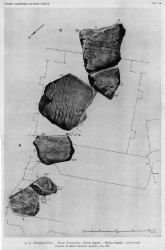
Identification: Templum Pacis In 1937, A.M. Colini joined these two fragments to fr. 15c, which contained the partial inscription [---]CIS, and identified the group as a large section of the templum Pacis, based on the similarity between the topography depicted on the fragments and the few uncovered remains of the building. The join between the pieces is not perfect but is confirmed by the aligning architecture and the veining of the marble (PM 1960, p. 73, with reference to Colini 1937). A small section of the building is also visible in fr. 16a. Constructed by Vespasian between 71 and 75 CE to commemorate his victory over the Jews and the destruction of Jerusalem, the Temple of Peace was in reality the third in the row of great imperial fora; not surprisingly, late antique sources occasionally refer to the building as forum Pacis or forum Vespasiani (LTUR IV, p. 67; Richardson 1992, p. 287). The Templum Pacis was a structure of great significance in antiquity as today: it gave its name to the 4th Augustan region; ancient sources such as Pliny (N.H. 36.102) proclaimed it one of the most beautiful buildings in Rome; it contained a library and the richest collection of art works known, including some moved from Nero's Domus Aurea ; and, most importantly in this particular context, after a fire in 192 CE, the building was restored between 208 and 211 CE by Septimius Severus, who subsequently placed in it his great marble map of Rome, now known as the Forma Urbis Romae (LTUR IV, pp. 67-68; Richardson 1992, pp. 286-87). The building was destroyed by an earthquake in 408 CE. but immediately restored. In the 6th c. CE, it was in poor condition (a lightning strike had caused yet another fire), and recent excavations suggest that it was used as a cemetary at that point (to read about the current excavation of the building, click here). Between 526 and 530, the S corner of the structure - including the wall that held the Severan map - was incorporated into the Church of Saints Cosmas and Damian (LTUR IV, p. 68, with references).
Remains uncovered in past and current excavations confirm the location and architecture of the Templum Pacis as represented in FUR fragments 15ab, 15c, and 16a. Built on the site of the old macellum, the building was situated northeast of the Forum Romanum, nested between the Basilica Aemilia to the southwest, the fora of Caesar and Augustus to the northwest, and buildings on the W slopes of the Velia to the east. It faced the Argiletum on the northwest, and its S corner approached the Via Sacra. It consisted of a large, almost square courtyard (134 x 137 m) that was surrounded on three sides by raised porticoes; its facade consisted of a single wall with rows of columns attached on both sides. Some of the exterior columns are still visible today; a few of those on the inside are depicted in fr. 16a. The principal entrance to the building would have been from the Argiletum through this wall; with the construction of Domitian's Forum Transitorium, however, what was presumably a large, central entrance was reduced to five(?) small and irregularly spaced openings from the Forum Transitorium and the Porticus Absidata, one of which is visible in fr. 16a. Raised porticoes framed the courtyard on the three remaining sides; they were accessed from the courtyard via steps. Rectangular niches, possibly two on each side, were situated in the backwalls of the two lateral porticoes; one of these is preserved underneath the Torre dei Conti (LTUR IV, p. 68, fig. 23; Richardson 1992, fig. 66). According to frs. 15ab and 15c, the courtyard contained six rows of elongated features, three on either side of a wide space along the central axis. Each feature consisted of four long rectangles connected by three short sections. Similar features are visible in the courtyards of the Templum Divi Claudi and the Adonaea. Whether these features represent hedges, large statue bases, fountains, or flower beds is still disputed (LTUR IV, pp. 68-69). However, recent excavations between the Via Alessandrina and the Via dei Fori have uncovered some of these features (visit the news section of the official web site for the Imperial fora). According to the preliminary results of these excavations, exhibited in the visitor's center of the Imperial fora, they seemed to have consisted of brick podia on top of which ran water channels that would have been flanked by ornamental shrubs and statuary. The thesis (Lloyd 1982) that the courtyard contained some form of garden structures thus seems confirmed. Fr. 15c demonstrates that a rectangular feature, probably a large altar, stood at the rear of the courtyard (LTUR IV, p. 69). The SE end held the principal parts of the complex: a central hall, flanked on either side by two smaller rooms or aulae, was situated behind the rear portico; it was slightly deeper than the flanking rooms. In front, it was faced with six columns on plinths; in the rear, a statue base within a shallow apse, visible in fr. 15ab, probably held a statue of Pax. A staircase with four steps led to the central hall from the courtyard through the rear portico. The six central columns of the rear colonnade were placed on plinths and aligned with those in front of the hall. Both the stairs and the columns on plinths matched the width of this substantial hall (LTUR IV, p. 69). As shown in fr. 15ab, the central room was separated from those flanking it on either side by a thick and a thin wall, in turn separated by a narrow space. The four side rooms would have opened onto the rear portico, and at least the two inner aulae might have been faced with columns like the central hall. The Severan Marble Plan hung on the SW wall of the aula to the immediate right (southwest) of the central hall. This wall is still preserved as are many of the holes left from the clamps that held the 150 marble slabs of the map. The wall opposite the Severan map of Rome was also faced with marble slabs; traces of paint on the marble pieces remaining from this wall suggest it depicted a geographical map (LTUR IV, p. 69).
The complex served many purposes, some of which are still disputed. In addition to serving as a temple to Pax, whose cult statue was placed in the apse of the central hall, the building is known to have had a library. Comparison to the architecture of the libraries of Hadrian in Athens and Celsus in Ephesus suggests that the library was housed in the central hall (LTUR IV, p. 69). The presence of numerous pieces of art in a garden setting made it a public art gallery and a recreational space similar to the Porticus of Pompey. Whether it inherited a commercial aspect from the macellum it replaced is uncertain but not unlikely (LTUR IV, p. 69). Central to the discussion of the function of the complex is the presence there of the Severan Marble Plan. Many scholars take this as evidence that the Templum Pacis also served as the headquarters and archives of the urban prefect of Rome (Gatti in PM 1960, pp. 216-217). F. Coarelli sees the architectural similarity between the Templum Pacis and other ancient libraries known to have served as archives for cadastral records as additional evidence that such was also its purpose (Coarelli in LTUR IV, pp. 69-70). D. Reynolds has convincingly argued that the marble plan did not have a utilitarian purpose as a cadastral or locator map, as has been assumed, but simply served to decorate the room that held the scrolls with the precise cadastral surveys on which the marble plan was based (Reynolds 1995, p. 125). For more detail about the map itself, refer to the map page of this site.
Significance Colini's identification of these fragments in 1937 revealed the true identity and location of the Templum Pacis, which had until then been confused with the neighboring Basilica of Constantine (LTUR IV, p. 67). The identification of the building was confirmed by the alignment of the architecture in this fragment and in fr. 15c which contained the partial inscription [---]CIS and comparison with actual remains (PM 1960, p. 73). Together with frs. 15c and 16a, these fragments provide important testimony to the architecture of the complex of which very little remains. Unfortunately, the section of the map that would have depicted the wall on which the Severan map was placed is missing; it would have been interesting to know if the engravers had highlighted this wall in any way to show its significance. Finally, fr. 15a gives a glimpse of the topography of the Velia before the construction of the Basilica of Constantine in the beginning of the 4th century.
|