ID AND LOCATION
| Stanford #
| 1abcde |
| AG1980 #
| 1a-e |
| PM1960 #
| 1 a-e |
| Slab #
| XI-6 |
| Adjoins
| none |
CONDITION
| Located
| true |
| Incised
| true |
| Surviving
| true |
| Subfragments
| 5 |
| Plaster Parts
| 0 |
| Back Surface
| smooth |
| Slab Edges
| 3 |
| Clamp Holes
| 4 |
| Tassello
| no |
TECHNICAL INFO
|
|
|
|
|
|
BIBLIOGRAPHY
- AG 1980, p. 57, pl. 1
- LTUR I: Area Radicaria (E. Rodríguez Almeida), pp. 119-120
- LTUR III: Mutatorium Caesaris (G. Pisani Sartorio), p. 335
- LTUR V: Via Appia (J.R. Patterson) pp. 130-133; Via Nova (J.R. Patterson), pp. 142-143
- Lott 2004, pp. 15-17.
- PM 1960, pp. 59-60, pls. 6, 15
- Richardson 1992, p. 33 (Area Radicaria); p. 264 (Mutatorium Caesaris); p. 414 (Via Appia); p. 417 (Via Nova)
|
|
|
Photograph (Mosaic) (1 MB)
Note about photographs | |
PM 1960 Plates: 6 15
AG 1980 Plates: 1
|
|
| IDENTIFICATION |
Imperial changing station (mutatorium Caesaris)
Customs post or vegetable market (area Radicaria) outside the porta Capena
The New Street (via Nova) and the Appian Way (via Appia)?
|
|
| INSCRIPTION
Epigraphic conventions used |
| Transcription |
1. [---]MVTATORIVM
2. AREARADICARIA
3. VI[---]
|
| Renaissance Transcription |
1. [---]MVTATORIVM
2. AREARADICARIA
3. VI[---]
(Cod. Vat. Lat. 3439 - Fo 16 r, reproduced at PM 1960, pl. 6, no. 3)
|
| Reconstruction |
1. MUTATORIVM (PM 1960; AG 1980)
2. AREA RADICARIA (PM 1960; AG 1980)
3a. VI[A
] (AG 1980)
3b. VI[A NOVA] or VI[A APPIA](PM 1980; LTUR III) |
|
|
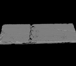
3D Model Full model | Top surface
Download the viewer | Note about 3D models |
|
|
| ANALYSIS
|
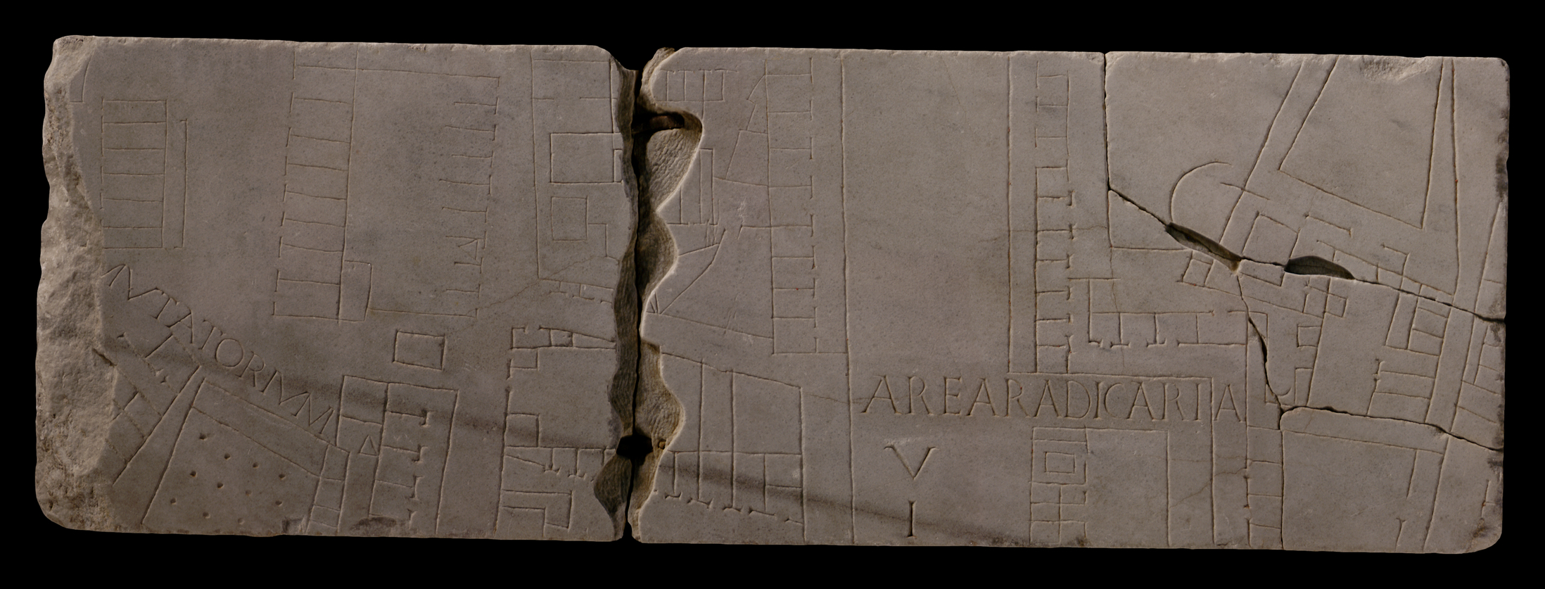
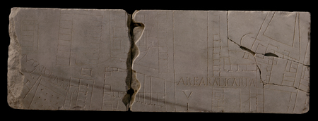
| Description The large fragment, consisting of five subfragments, almost constitutes an entire slab. The top, right, and bottom sides are slab edges. Four clamp holes are visible on top and on the right;
along the bottom edge, two rectangular areas have been chiseled away to accomodate the clamps from the adjoining slab(s). Only frs.
10g,
28c,
31dd,
138c,
329,
338, and
604
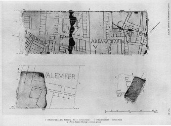
display similar marks, which are generally found on the bottom edge of the slabs. The ductus of the incisions in the upper left corner is not as deep as those elsewhere on the fragment. A wide, vertical street, incompletely labeled VI[-], and a smaller, parallel street to its left, divide the depicted architecture in three sections. The leftmost section consists of four separate structures: top left lies a vertical row of left-facing tabernae. The function of the short line that runs parallel to the back of the shops is uncertain. To the right of these shops, across an open plaza, lies a rectangular structure fronted with outward-facing shops on the left and on the right. Those on the right face the narrow, vertical street but do not seem to have back walls; instead they open onto a large, common hall or courtyard. A set of stairs in one of the rooms indicate that the structure had more than one level. The row of rooms on the left continues beyond the top edge of the slab. Between this building and the one below lies a small, rectangular feature, perhaps an altar, a statue base, a grave monument, or a basin. In the bottom left corner of the fragment, two structures are visible; they are separated by a narrow alley and are placed at an odd angle in relation to the architecture above and to the right. The inscription MUTATORIUM runs across the triangular space in front, perhaps serving a joint label for both buildings. The structure on the left is a complex of small rooms, most of which have no visible openings; the one on the right shares a common wall with but does not seem to have access to a row of tabernae that faces the narrow, vertical street. (Note that the line that denotes a wall or a sidewalk in front of these tabernae is missing from the drawing in AG 1980, pl. 1.) The main building consists of a large room or open space, filled with four rows of three dots (columns?). Small rooms with no visible access line it on the right, and an elongated room - perhaps a portico - fronts it. The two structures in the middle section are separated by a narrow, horizontal street The building at top seems to be surrounded by a wall on the left and on the bottom; on the right it is fronted by a row of shops that faces the wide, vertical street. Within the walls and the back wall of the shops lies an array of rooms of various sizes and shapes. The authors of PM 1960 (p. 59) presumed the entire structure was covered, but the irregular shapes of some of the larger features within speak against this. The building below is surrounded by a wall on all sides, and a horizontal wall divides it into at least two sections. A small opening in the top left side gives access to the top section which consists of a large, rectangular space and two smaller rooms in the back with no visible openings. The bottom section is a large space faced at top by a row of shops. The wide, vertical street is outlined on the left by a single line, perhaps a low wall or a raised sidewalk. The third architectural section occupies the entire right third of the fragment. A narrow street breaks away from the wide, vertical street towards the right and then down, thus framing a rectangular building between it and the wide street. The horizontal inscription AREARADICARIA begins in the wide street and continues into the smaller street. The rectangular structure below the inscription seems to be a large courtyard with rooms on the left side only. One of the rooms is larger than the others and contains a small, rectangular feature, perhaps an altar. Tabernae back onto the right side of the wide, vertical street and face the "dogleg" created by the smaller street. Here, it is fronted by a continuous line which seems to denote a sidewalk. The space behind these three rows of shops, in the upper right corner of the fragment, is occupied by a gargantuan structure whose orientation is slightly skewed in relation to the streets. It consists of a variety of small and large, regular and irregular rooms and open spaces. Two curved features are visible within (note that the smaller of the two curves is missing from AG 1980, pl. 1). Two additional buildings in the lower right corner are separated from, but share common walls with this large complex and with the vertical, left-facing row of shops in the bottom right corner.
Identification: Slab XI-6 The inscriptions in this fragment label two buildings one of which is known to have been located in Regio I (mutatorium Caesaris), the other in Regio XII (area Radicaria). The fragment thus shows the division between the two regions, which corresponded to the valley between the Caelian and the Aventine Hills (PM 1960, p. 59). On the map, this location corresponds to the top center row of slabs, and the clampholes in the fragment do indeed match those in the wall of the aula at top center (see PM 1960, figs. 36-40). [input David's position here] The height of the fragment, 36,5 cm, provides the height of the entire top row of slabs.
Identification: Mutatorium Caesaris The inscription MUTATORIUM in the left side of the fragment seems to have labeled the mutatorium Caesaris, a building which is known from the Regionary Catalogues to have been located in Regio I. The secure position of the piece locates the complex to an area just west of the base of the Caelian hill, in front of the Baths of Caracalla, and outside the Porta Capena. No remains of the structure(s) have ever been discovered in this area. In this fragment, the label may refer to the entire group of buildings left of the vertical street on the left. The exact function of the imperial mutatorium is uncertain; it has been suggested that it served as a station where members of the imperial administration changed from a city litter to a travelling carriage when leaving town, and that the colonnaded hall with the adherent rooms functioned as a stable for the horses. Another proposal identifies the mutatorium Caesaris as the place where the emperor changed from his toga into the paludamentum in accordance with the rituals of the profectio and the adventus (LTUR III, p. 335).
Identification: Area Radicaria This area is only known from its label on this FUR fragment and from its listing in the Regionary Catalogues under Regio XII. From these two sources it can be located on the S edge of the Via Appia, outside the Porta Capena, and in front of the mutatorium Caesaris on the slopes of the Caelian Hill (LTUR I, p. 119). The etymology of the name radicaria is uncertain; E. Rodríguez Almeida has suggested it stems from radius, which he identifies as the tool by which grain was smoothed out when measured (hostorium). He proposes that the inscription therefore referred to a customs area immediately outside the Porta Capena and associates the building surrounded by the "dogleg" in the bottom center of the fragment with a customs office (LTUR I, p. 120). Or, might it refer to a vegetable market (LTUR V, p. 132)?
Identification: compital shrine? Lott suggested that the small, rectangular feature on fragement 1a may be a compital shrine, a neighborhood worship place located at crossroads (Lott 2004, p. 17).
Identification: via Nova and Via Appia? The wide, vertical street that traverses the entire slab just right of the center is now generally identified with the via Nova, a street built by Caracalla in front of his new baths (PM 1960, p. 60; LTUR V, p. 142 with sources). To solve the problem of how this street, associated with the thermae Antonianae which were inaugurated in 216 CE, could appear on the FUR, which was carved somewhere between 203 and 211 CE, the conception and creation of the closest stretch of the 30 m wide street is generally attributed to Septimius Severus, who wanted a grand approach to his Septizodium (PM 1960, p. 60; LTUR V, p. 142). The fate of the Via Appia after the creation of the Via Nova is uncertain. Some suggest the Via Nova replaced a stretch of the Via Appia (PM 1960, p. 60); others propose the Via Nova ran parallel to the Via Appia, between it and the Baths of Caracalla, and that it was oriented on the entrance to the Circus Maximus and not the Porta Capena (LTUR V, p. 142; LTUR I, fig. 80). In the latter case, we should associate the vertical street to the left of the Via Nova in this fragment as the Via Appia. This is not unlikely, as the imperial changing station (see mutatorium Caesaris above) where the emperor would change his travel equipage and/or change from military to civilian clothing upon returning from a campaign, is located right off this street.
Significance The fragment provides the height of the entire upper row of slabs of the map. [If David can move the slab to the right to align the wide street with the entrance to the Circus Maximus, it would solve the problem of the orientation of the Via Nova] The fragment also provides a vivid picture of the area outside the Porta Capena, the major entrance to the city from the south: where it had been a desired site for temples and grave monuments of Rome's elite families in the Republican period, by the beginning of the third century CE the area had developed into a busy center of commerce and transport -- all prompted by the importance of Via Appia and later the Via Nova.
|
|
| HISTORY OF FRAGMENT |
| Upon its discovery in 1562 in a garden behind the Church of Saints Cosmas and Damian and subsequent transfer to the Palazzo Farnese, this famous fragment was still in one piece. This is proven by the 16th-c. drawings that reproduced the fragment and which now are kept in the Vatican (Cod. Vat. Lat. 3439-Fo 16 r, reproduced at PM 1960, pl. 6, no. 3). Another Renaissance drawing, the Codex Barberinianus Latinus 4423, shows only the left half of the fragment, thus proving that it had broken in two pieces already by that time (see PM 1960, pl. A, fig. 2). Giovanni Pietro Bellori also included it in his 1673 publication of the Plan. In 1742, the fragment, now in five pieces, was moved to the Capitoline Museums and exhibited with some of the other known fragments in wooden frames along the main staircase. In 1903, museum curators included the piece in a reconstruction of the FUR mounted on a wall behind the Palazzo dei Conservatori (1903-1924). It was probably at this point that the top edges of the central break were smoothed out. In 1924, it was moved with the other known FUR fragments to the Antiquarium Comunale, where it was exhibited (1924-1939). Since 1939, it has been stored with the other known FUR fragments in various places: the Capitoline Museums again (1939-1955), the Palazzo Braschi (1955-1998), and since 1998 in the Museo della Civiltà Romana in EUR under the auspices of the Sovraintendenza ai Beni Culturali del Comune di Roma. (This fragments history corresponds to Iter A as summarized in PM 1960, p. 56.)
Text by Tina Najbjerg
|
|
| KEYWORDS
|
| street, customs, shops, tabernae, column, portico, sidewalk, tomb?, fountain?, basin?, courtyard, stables?, |
|