ID AND LOCATION
| Stanford #
| 247 |
| AG1980 #
| 247 |
| PM1960 #
| 247 |
| Slab #
| unknown |
| Adjoins
| none |
CONDITION
| Located
| false |
| Incised
| true |
| Surviving
| true |
| Subfragments
| 1 |
| Plaster Parts
| 0 |
| Back Surface
| smooth |
| Slab Edges
| 0 |
| Clamp Holes
| 0 |
| Tassello
| no |
TECHNICAL INFO
|
|
|
|
|
|
|
|
|
|
|
| ANALYSIS
|
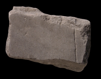
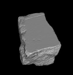
| Description A vertical line traverses the fragment to the right, defining one edge of a large, open space. What might be a parallel guide line is visible left of it.
Identification There were many blank areas on the Marble Plan. These included the spaces occupied by the Tiber River, by gardens, arenas, temple precincts, courtyards, or from the edges of the Map --in short, any space devoid of architecture or human construction. This fragment could have belonged to any of those areas. Unless the line defined an edge of a bridge, the piece did not depict a section of the Tiber River, however. The edges of the Tiber were not engraved on the Marble Plan, and even if they had, they would not have been straight as the line in this fragment. An examples of a guide line that runs parallel to a straight, carved line as in this fragment can be seen in fr. 8c.
Significance 3D digital matching may help attach this fragment to larger, developed areas of the Plan and thus enable us to identify the nature of this large open space within the Roman cityscape.
|
|
| HISTORY OF FRAGMENT |
| Like the majority of FUR fragments, this piece was discovered in 1562 in a garden behind the Church of Saints Cosmas and Damian. From here, it was transferred to the Palazzo Farnese and stored there. The fragment was later used as building material in a 17th c. Farnese construction, the Secret Garden, and it was rediscovered in 1888 or 1898 when the walls of the garden near the Via Giulia were demolished. Since then, it has been stored with the other known FUR fragments in various places: The storerooms of the Commissione Archeologica (1888/1898-1903), the Antiquarium Comunale (1924-1939), the Capitoline Museums (1939-1955), the Palazzo Braschi (1955-1998), and since 1998 in the Museo della Civiltà Romana in EUR under the auspices of the Sovraintendenza ai Beni Culturali del Comune di Roma (This fragments history corresponds to Iter E as summarized in PM 1960, p. 56). N.B. PM 1960 does not reveal the whereabouts of the fragment between 1903 and 1924.
Text by Tina Najbjerg
|
|
| KEYWORDS
|
| open space, guide line |
|