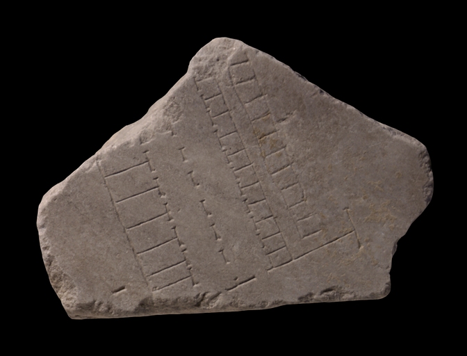
| Description The bottom edge of this fragment is part of a slab edge. There is a single, deep dash in otherwise empty space at lower left; this may be damage rather than a topographic incision. Three rows of rooms run down the center of the fragment, all ending at a horizontal line. There is empty space below this line and at the left and right sides of the fragment. At left, empty space yields to a vertical row of large rectangular rooms, all backed by a single wall to the left and each with a doorway opening onto a space at right. Seven rooms are visible in this row before the fragment break; the second from the bottom is narrower than the others in this row. Less than 3cm (i.e. just under 7m on the ground) to the right of this row and parallel to it is a dashed line indicating an arcade. The openings in the arcade do not match the openings in either row of flanking rooms. The same distance on the other side of the arcade separates it from a second vertical row of individual rooms, these much smaller than the first and each one opening into the space to the left. The entire row of twelve visible rooms before the fragment break is backed by a single wall.
To the right of this complex is a passage or alleyway, closed on both sides by the walls of the two flanking rows of rooms. The passageway seems therefore to be for movement from one end of the complex to another, rather than for access into the individual spaces. Alternatively, access into the spaces on the right was from above (see below), in which case this passage may have provided access to them. Beyond the passage to the right is a final row of rooms; eleven are visible below the fragment break. This row is made up of small spaces, like those of the row immediately to the left, but with a variety of openings, or none, into the individual rooms. The bottom two rooms are entirely open to the right; a long set of middle rooms has no visible opening at all; the top two and perhaps the third as well have doorways opening to the right. Complicating matters is the left wall of this row, sloppily carved and looking like a later, hasty addition to the previously incised side walls of these rooms. This may indicate that doorways were supposed to fall along the left side of this row of rooms but were left out by the carver of this sloppy line. Alternatively, these seemingly sealed spaces were reached in some other way, e.g. by ladders from above if they were pits or storage units of some kind. The absence of visible doorways may also indicate a rise or drop in the ground level along these rooms. This row ends before the perpendicular line at the bottom of the fragment, leaving room for the passageway to turn to the viewer's right and continue into the empty space beyond this complex to the right. All three parallel rows of rooms and the arcade end at a perpendicular line running across the bottom of the fragment. Two openings in this perpendicular line provide access into the spaces on either side of the arcade bisecting the central complex. The line ends in a T shape at the right, well beyond the rows of small rooms.
Identification: A commercial building The leftmost row of large rooms and the row of small rooms facing it to the right both open onto a central space divided by a single arcade. The left, bottom and right of this building are marked by lines denoting solid walls; the upper part of the building continues beyond the fragment break. This arrangement of small rooms around a rectangular central space is typical for commercial buildings, warehouses and barracks; the small rooms may be tabernae, storage spaces, or cell-like rooms for sleeping. This building is unusual, however, in having an arcade bisecting the central courtyard space, i.e. the vertical line of dashes indicating a wall interrupted by somewhat irregularly spaced openings. In many other instances, the function of this kind of dashed line is clear. Between a street and a street-front row of shops, for example, this kind of line would indicate an arcaded front to a covered sidewalk; around the Circus Maximus, such a line represents the arched doorways into the building. On this fragment, the arcade divides the space between two facing rows of rooms or shops into two spaces of ca. 7m each, spaces that might or might not be roofed. Several reasons to divide a space in this way can be imagined. One might be purely architectural; a wall with multiple openings running down the middle of the space might help support a roof without impeding the flow of traffic across the space. Alternatively, perhaps material goods of some kind were usefully kept separate while the people working with those goods retained free access between the two sections. Or the goods themselves might need to be sorted, sold or processed in different phases. Less likely is that the arcaded wall has no connection to the space, as might be the case for an aqueduct running through an area; aqueducts on the plan are indicated more elaborately than this simple dashed line. On the other hand, aqueducts are incised in several different ways; it is not excluded that this is another variation.
Identification: Buildings on the riverbank (or at the foot of a hillside) The horizontal line at the bottom of the fragment provides clues that these structures may lie along the river. It closes all three rows of rooms as well as the arcade, and protrudes well beyond the point where they end. It has two openings providing access to the arcaded space of the central building. Above this horizontal line, the rightmost row of rooms ends so as to leave space for access from the right into the passageway between the two rows of small rooms. One way to interpret these features is to consider that the Tiber River may run along the right edge of the fragment, parallel to the rows of rooms and the arcade. In the Emporium area there are several instances of riverbank buildings and rows of rooms running parallel to the river, as well as rows of rooms right on the riverbank that are entirely open, or have no doorways at all (e.g. fr. 24d, or the middle building on fr. 25a). If the open space at right is indeed the Tiber flowing parallel to the rows on this fragment, then the complex as a whole makes good practical sense. The row of rooms on the right might serve immediate purposes of unloading or storing loading and unloading equipment, while the building just inland is then organized to take commercial advantage of goods offloaded from the river. The horizontal line in this case finds a good parallel to a similar feature at the bottom of fr. 25a, depicting the Horrea Lolliana; these perpendicular lines may divide individual complexes from one another. Another possibility is that the horizontal line at the bottom of the fragment is a retaining wall at the start of a steep hillside; this would explain why the building complex ends here. This might also bolster the slender possibility that the dashed line is an aqueduct, which in that case would properly move underground into the hillside at such a point. Arguing against this hypothesis are the two openings in the horizontal line; they provide access into the central building, which does not match what we would expect of a retaining wall. It may well be that the area below this line and its doorways is as flat as the area just above. The horizontal line also might simply mark a property line, or the beginning of an open space below demarcated for a particular use and hence kept free of buildings.
Identification: A commercial zone of the city, not densely packed This fragment depicts plenty of open space, a rectilinear arrangement of architecture and rooms, and no staircases indicating upper floors--it appears to show an area of the city that was flat and not densely packed with buildings. The many single rooms disposed in rows and the lack of other kinds of architectural arrangements recall the low density found on the Plan in Transtiberim or in the Emporium area of warehouses and commercial establishments along the Tiber bank.
Significance Comparison with identified riverfront structures suggests that this fragment too may lie along the river. This kind of comparative analysis may help us position unidentified fragments within the Plan as a whole. That is not their only value, however; fragments like 259 provide irreplaceable insight into the nature of the urban fabric and the organization of different kinds of space in the city. |