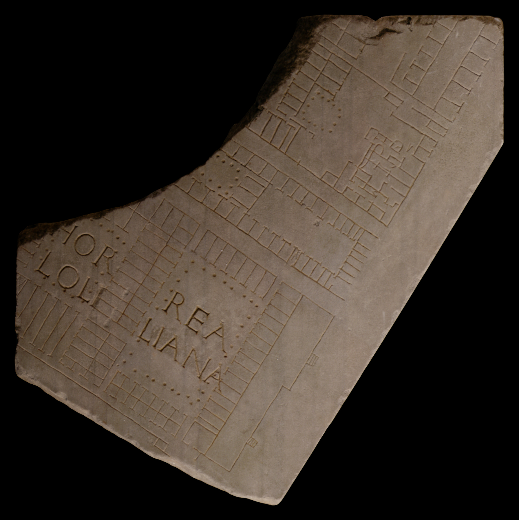
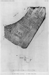
| Description This large piece touched three sides of a slab. Two complete and two partial clampholes are visible, as is a partial tassello on the back. The fragment depicts portions of four or five separate building complexes, divided by three streets or alleys. A wide open space flank these buildings on the right. Across the bottommost complex is inscribed HORREA LOLLIANA. A mistake is evident in the inscription after the second L; perhaps the engraver thought better of starting a new letter there. This complex is divided into two distinct but connected areas, each consisting of rows of fairly uniform rooms suggesting storage flanking a large courtyard. Access is controlled between the two courtyards by means of a long passageway. A staircase is represented by a triangle in the lower lefthand corner of the complex. According to Pedroni 1992, the three crossbars in the triangle indicate that the stairs gave access to three storeys. On the righthand side of the building is depicted a wide platform, perhaps for unloading of goods, with two sets of staircases leading down to the open space. Other interesting features include possible guardrooms along the bottom of the complex and a set of very long and narrow passageways along the bottom of the lefthand courtyard.
Across a narrow street is depicted another complex whose bottom righthand doorway is aligned exactly with the top righthand doorway of the horrea Lolliana. A set of stairs almost blocks the entrance. This building is likewise divided into two distinct areas, albeit not connected, each consisting of a courtyard flanked by uniform rooms. Most of the left side of the complex is missing, but it appears that the left courtyard was surrounded by a colonnade. The row of rooms on the righthand side of the righthand courtyard appears to be open towards the right, but it is possible that the engraver neglected to add the necessary line closing off the building.
A large, rectangular structure is situated above the second complex. Although much of its left side is missing, this section appears to have been similar to the two buildings below, with rows of inward-facing rooms flanking what was possibly a courtyard. The right side of the structure is quite different, however. Here, it consists of a large open space with a freestanding peristyle flush with the rooms at the left. To the right of the open area is a labyrinth of rooms, highly compartmentalized, with tightly controlled access from the street at the upper right of the complex. The block of rooms is divided into two halves that were apparently unconnected, unless some of the lines represent changes in levels rather than walls. There may be some sort of platform connecting the two halves indicated by the feature engraved over the dividing line between halves. Triangles on both sides of the complex perhaps indicate staircases. Horseshoe-shaped curves in the upper half of the complex may represent basin structures. Access between the left and the right half of the building was restricted to a very narrow passageway through the peristyle. At top of the fragment, a row of rooms (tabernae?) faces the river. An alley or corridor separates it from a parallel row of rooms behind it. Across a rectangular open space these rooms face a row of back-to-back tabernae.
Identification: Horrea Lolliana
The lower complex has been identified as the horrea Lolliana, a building complex in the Emporium district (Region XIII) at the Tiber wharves (PM 1960, pp. 83-84; Staccioli 1962, pp. 1434-1435, Rickman 1971, pp. 109-112). A handful of inscriptions (CIL 6, 4226, 4239, 9467) support the existence of this building; they refer to officials, perhaps imperial slaves (vilicus), from the horrea Lolliana. Construction of the building has been attributed variously to the father of Lollia Paullina, M. Lollius, to her grandfather of same name who was consul in 21 BCE, or to one of Pompey's followers, M. Lollius Palicanus (LTUR III, p. 43). Remains of a large brick structure between the Lungotevere Testaccio, Via G. B. Bodoni and Via B. Franklin (unpublished but see Lanciani 1893-1901, pls. 43 and 44), in the exact spot where the Marble Plan indicates the building was located, support a Republican date for the horrea Lolliana. The alignment of the upper righthand doorway of the horrea Lolliana complex and the lower righthand doorway of the building complex immediately above it on the fragment suggest that these two complexes may have functioned together as part of a riverfront checkpoint/storage operation for the processing and distribution of goods arriving at the wharves.
The unloading area/dock is only fifteen meters at its widest. Although the courtyard areas would have facilitated a certain amount of sorting, measuring, and checking upon arrival, the high volume of river traffic combined with the limited space for unloading of goods argues for a good deal of sorting and organization before the goods left Ostia or Portus.
The two courtyards may represent distinct staging areas for the checking, sorting, and distribution of goods. The rows of rooms facing outward from the bottom of the righthand courtyard could be interpreted as tabernae, but their prime riverfront location and the high flow of traffic from the docks that would have passed in front of them argue against this. It is possible that they were reception areas for shippers to submit inventory tallies to horrea officials. An entrance at the upper righthand of the first (righthand) courtyard is aligned exactly with an entrance to the horrea complex directly above it. This would greatly facilitate the movement of goods from the horrea Lolliana into the adjoining warehouses, perhaps for temporary storage after the initial sorting process, suggesting the importance of considering how neighboring buildings functioned together.
Storage in the rooms around the courtyard, as well as in the upper stories, was also possible. Goods could be carried through a passageway from the first (righthand) into the second (lefthand) courtyard for distribution. The long narrow passages at the bottom of the second courtyard may have admitted queues of porters for the distribution of goods throughout the city. The lack of space in front of and around this building suggests that this is a more likely possibility than that the grain dole was administered directly from the horrea Lolliana. Porters and dockworkers familiar with established routes of ingress and egress are much more suited to the narrow alleys and passageways than queues of rowdy Romans. FUR frs. 28a and 28c, also horrea complexes along the Tiber, show similar degrees of compartmentalization and interconnectedness, although access to these horrea is more restricted than to the horrea Lolliana, perhaps implying longer-term storage. Nevertheless all these Tiber horrea suggest the importance of considering how the buildings in the Emporium district functioned together as a system for the reception, checking, and distribution of goods throughout Rome rather than dealing with them as isolated long-term storage facilities.
Identification: Headquarters of a collegium?, including a small bath The third building from the bottom is generally interpreted as a bath complex (PM 1960, p. 85; Staccioli 1961, p. 98-99), although it is difficult to draw comparisons between this fragment and others more easily identifiable as baths on the Marble Plan. E. Rodríguez-Almeida identifies it, albeit tentatively, with the baths of Tigillinus (balnea Tigillini) (Rodríguez-Almeida 1995-96b, p.383). An interesting proposal has been put forth by R. Staccioli, who suggests that the entire right side of this structure was the headquarters (schola) of a professional organization or society (a collegium), perhaps of dock workers. The restricted access to the building (in the top right corner) supports this interpretation, which is also confirmed by B. Bollmann (Bollmann 1998). Use of the bath would have been restricted to members of the guild; the peristyle would have provided ample space for meetings and communal meals, and it may even have held a statue of the guild's patron god (Staccioli 1968, p. 25).
Identification: Tiber River The blank space along the right side of the fragment represents the Tiber. Italy's third longest river, the Tiber winds its way through Rome about 25 km before it drains into the Tyrrhenian Sea. In antiquity, only Tiber Island and perhaps eight bridges interrupted its 5.6 km long stretch between the Aurelian Walls (see LTUR V, fig. 46). For the Romans, the Tiberis (other appellations were Albula, Thybris and Tiberinus) was a provider of both bounty and frustration. It was the vital trade route between the city and the outside world; fishing in its waters provided food; and until the construction of Rome's aqueducts it was the major source of drinking water. However, the Romans struggled endlessly to keep the waterway navigable and to control the violent and frequent floods. Commercial buildings such as the horrea seen here were constructed along its banks as early as the 2nd c. BCE., and later the villas, horti, and mausolea of the upper class vied for space along the river with the apartments and cemetaries of the less fortunate (LTUR V, pp. 69-73). Remains of these buildings, especially of the commercial structures and the cemetaries and residences of the poorer classes, were largely destroyed when retaining walls were constructed on both sides of the river at the end of the 19th c. (It was during the construction of the Tiber embankment along the Via Giulia in 1888 or 1898 that a plethora of FUR fragments was discovered.) The appearance of these non-monumental structures on the Marble Plan is therefore of great importance.
Despite its important role in Rome's economy and social and political history, the Tiber is not outlined on the Marble Plan. It appears simply as a blank space whose shape is discernible only through the construction that frames it on both sides (see for example fr. 24d). Although color was used to highlight certain buildings and streets on the Plan, there is so far no evidence to show that the river was emphasized in any way (except a possible label, Tiberis, inscribed in fr. 200b[Rodríguez-Almeida 1992, pp. 59-60]).
Significance
The Horrea Lolliana represent the only labeled horrea complex that the Marble Plan provides. Given the date of the Marble Plan, we have to assume that this representation of the horrea Lolliana reflects the particular needs of the city with regards to grain/food distribution at the beginning of the third century CE. The location of this complex on prime riverfront property, the buildings relative compartmentalization and high, albeit controlled, amount of access when compared with horrea from Ostia, all suggest that in spite of the label horrea (which normally indicates a storage facility), this structure was used for the checking, sorting, short-term storage, and distribution around the city of goods unloaded from riverboats. The obvious comparison is with the Porticus Aemilia (FUR frs. 23, 24b, and 24c).
|