ID AND LOCATION
| Stanford #
| 26 |
| AG1980 #
| 26 |
| PM1960 #
| 26 |
| Slab #
| VII-7 |
| Adjoins
| none |
CONDITION
| Located
| false |
| Incised
| true |
| Surviving
| false |
| Slab Edges
| 0 |
| Clamp Holes
| 0 |
| Tassello
| no | |
|
|
|
|
|
|
|
|
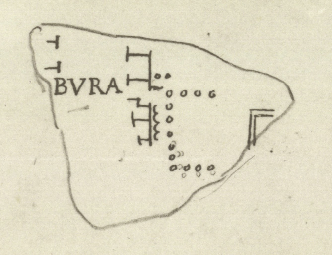
Detail from Cod. Vat. Lat. 3439 - Fo 19r,
reproduced from PM 1960, pl. 9 | |
PM 1960 Plates: 9 25
AG 1980 Plates: 18
|
|
| IDENTIFICATION |
| Renaissance drawing: A section of the Subura neighborhood (Subura) including latrines and a possible temple
|
|
| INSCRIPTION
Epigraphic conventions used |
| Transcription |
| None; the fragment itself is missing
|
| Renaissance Transcription |
| [---]BURA
|
| Reconstruction |
| [SU]BURA (PM 1960; AG 1980) |
|
|
|
|
|
| ANALYSIS
|
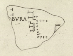
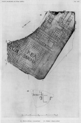
| Description The fragment is lost but Renaissance drawing Cod. Vat. Lat. 3439- Fo 19r shows it as it looked (see detailed photo above or PM 1960, pl. 9, no. 8). A vertical street traversed the fragment, making a slight turn towards the right at the bottom. Along the top stretch, it was flanked on both sides by tabernae. The letters [---]BURA were inscribed across the street. One of the shops or rooms along the right side of the street gave access to a large, rectangular space surrounded on three sides by columns. Between the back of the tabernae and the colonnaded space a vertical wavy line was visible, and above the entrance were two columns. On the far right, one can barely make out the upper left corner of a room, rendered with double lines.
Identification: Subura The inscription in this lost fragment identifies the area depicted as part of the residential and commercial district called the Subura. Archaeological and epigraphical evidence, in conjunction with the names of Medieval churches and quotes from Martial, locate the approximate boundaries of the Subura neighborhood. It began near the Argiletum and the Roman Forum, and from there stretched, at least in imperial times, northward up the valley between the Quirinal and Viminal Hills and eastward between the Oppian and Cispian Hills, where it probably reached as far as the Esquiline Gate (LTUR IV, p. 379). An inscription (CIL 6.9526) indicates that in the imperial period the area was divided into two sections: the Subura maior and the Subura minor. The greater Subura has been identified with the largely commercial area near the Forum Romanum, between the Viminal and the Oppian Hills, and the lesser Subura with the upper section between the Cispian and Oppian Hills, where the major thoroughfare of the Subura, the clivus Suburanus, ascended towards the Esquiline Gate (LTUR IV, p. 380).
Roman poets like Martial and Juvenal described the Subura as a sordid commercial area, riddled with violence, brothels, and collapsing buildings. In reality, it was probably not different from any other neighborhood in Rome where commercial activity intermingled with the religious and political life in the great public monuments and smaller local shrines and scholae, and where the large domus of the rich stood next to the decrepit apartment buildings that housed the poor. An abundance of evidence demonstrates that even in Imperial times the Subura housed senators (probably on the upper slopes) as well as sandal makers, blacksmiths, and cloth sellers (LTUR IV, p. 382).
The colonnaded building remains unidentified. G. Carettoni noted the double rendering of the walls to the right of the colonnade, a technique usually reserved for temples on the Marble Plan, and tentatively suggested that what was represented here were the pronaos and cella of a temple, perhaps that of Tellure (PM 1960, p. 84). The wavy line in front of the "temple" he suggested represented latrines (a similar rendering of latrines, known from excavation, is seen in fr. 37a).
Significance The colonnaded space, perhaps representing a temple, the latrines, and the rows of shops depicted in this fragment produce a vivid picture of a neighborhood where religious monuments intermingled with functional and commercial structures. |
|
| HISTORY OF FRAGMENT |
| Like the majority of FUR fragments, this piece was discovered in 1562 in a garden behind the Church of Saints Cosmas and Damian. From here, it was transferred to the Palazzo Farnese and stored there. Renaissance engravers reproduced the fragment in 16th-c. drawings that are now kept in the Vatican (for more information about the creation and accuracy of these drawings, see Cod. Vat. Lat. 3439), and Giovanni Pietro Bellori included it in his 1673 publication. The whereabouts of the piece after this date are unknown. (This fragments history corresponds to Iter D as summarized in PM 1960, p. 56.)
Text by Tina Najbjerg
|
|
| KEYWORDS
|
| temple?, colonnade, street, tabernae, subura, latrines |
|