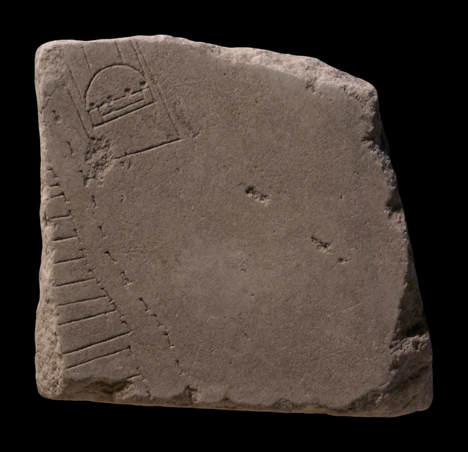
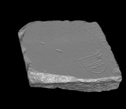
| Description The fragment was part of a slab edge. It depicts a large blank area to the right which is flanked on the left by an uneven row of tabernae fronts, faced with an arcade or covered colonnade. In the blank area at top, right next to the arcade, the end of an unusual structure is visible. It consists of a platform on top of which sits the actual building. Two wide steps, flanked by perpendicular edges or narrow platforms, lead to the front of the building. Immediately above the steps an arch, perhaps a barrel vault, stretches across the width of the structure. Four columns are spaced regularly along the flat end of this arch. Two elongated lines, parallel to the sides of the building, emerge from the curve of the arch.
Identification: Riverfront tabernae Having identified the blank space in this fragment and the joining fr. 32gh as the Tiber and riverfront structures along it, E. Rodríguez-Almeida used this information together with the position of the clamp hole in fr. 32h and the thickness and smooth back of the fragments, which are similar to the already securely positioned fragment group 32, to locate both this fragment and fr. 32gh in the bottom left of slab V-13 (Rodríguez-Almeida 1977, pp. 248-250, fig. 11; AG 1980, pp. 116-118). This position was later confirmed by the discovery of the via Anicia plan which depicts the same area (among the many publications on the via Anicia plan and its relationship to frs. 32gh and 32i, see M. Conticello De'Spagnolis, Il tempio dei Dioscuuri nel Circo Flaminio [Rome 1985]; Rodríguez-Almeida 1988; and Tucci 1996b, 1994, and 1993). On the via Anicia plan, the tabernae that also appear in this fragment are labeled with an inscription, CORNELIAE ET SOC, suggesting the building with the riverfront shops either belonged to these people or was built by them (see Rodríguez-Almeida 1988, fig. 2). The via Anicia plan dates to the first century CE, however, and there is, of course, no guarantee that the building had the same owners in the 3rd cent. CE, when the Severan Marble Plan was carved.
Identification: Unidentified platform building The function of the unusually shaped platform structure in this fragment is still disputed. It has been identified as a fountain or a nymphaeum (PM 1960, p. 152).
M. Conticello De'Spagnolis (1985) has proposed that it represents a part of the Navalia.
E. Rodríguez-Almeida identifies the structure as the statio alvei Tiberis, the headquarters of those associated with the cura alvei Tiberis et riparum (Rodríguez-Almeida 1988). The discovery of the via Anicia plan in Trastevere, and the existence nearby of an inscription that once must have labeled the statio alvei tiberis, both in close proximity to the area depicted in the new fragment, points to the association of the rectangular building with the caretakers of the river. The Via Anicia plan was probably an official document, published by the cura alvei Tiberis et riparum and posted close to the statio, which is represented by the rectagular building in the via Anicia plan itself and also in this FUR fragment.
Finally, P. L. Tucci identifies the building as a museum for the Ship of Aeneas (Tucci 1997). In a passage from Goth. 4.22, the 6th-century author Procopius describes how the Romans have preserved, even to his day, the ship of Aeneas, which is placed in a neosoikon in the center of Rome, along the edge of the Tiber. Tucci suggests that the ship was a relic from the 4th century BCE, and the structure that held it (the neosoikon) had the shape of a regular roofed stall for ships, except it would not have been made of wood but of stone, it would have been raised on a tall platform, and would have functioned as a museum. He proposes that this museum was built by Augustus as part of his program to celebrate his ancestry and direct link to Aeneas, as seen in the Ara Pacis and in Forum of Augustus. This would not have been the first ship museum Augustus built. After his naval victory at Actium in 31 BCE, Augustus founded Nicopolis and built a temple dedicated to Apollo, Neptune and Mars, decorated with ships' prows. In addition, Strabo relates that Augustus preserved ten ships from Marc Antony's fleet and on the beach below the temple to Apollo, where the battle had taken place, he constructed ten neosoikoi for these ships. The neosoikoi at Actium were destroyed by a fire and are no longer preserved. A late 4th-century BCE ship museum on Delos, however, is partially preserved. In front, the Delos monument was shaped like a deep hexastyle
pronaos to a temple, similar to the front of the structure in this fragment. In addition, Procopius describes the ship of Aeneas as being 120 feet long and 25 feet wide (35 x 7 meters) which corresponds with the dimensions of the Tiber building, as it is represented in this fragment and the via Anicia plan. Like Demetrius Poliorcetes or his son Antigonos Gonatas had the Delos monument constructed as a memory of their naval victory over Ptolemy I or the II, so Augustus and Agrippa probably had the Tiber monument constructed as a memory of their naval victory over Marc Antony and Cleopatra, the last descendant of the Ptolemies. The monument along the Tiber would have been tall enough to have been visible from the Circus Flaminius, where Augustus would have celebrated his Actium triumph.
Identification: Tiberis E. Rodríguez-Almeida identified the blank area to the right of the stipled line in this fragment as the Tiber (Rodríguez-Almeida 1977). Italy's third longest river, the Tiber winds its way through Rome about 25 km before it drains into the Tyrrhenian Sea. In antiquity, only Tiber Island and perhaps eight bridges interrupted its 5.6 km long stretch between the Aurelian Walls (see LTUR V, fig. 46). For the Romans, the Tiberis (other appellations were Albula, Thybris and Tiberinus) was a provider of both bounty and frustration. It was the vital trade route between the city and the outside world; fishing in its waters provided food; and until the construction of Rome's aqueducts it was the major source of drinking water. However, the Romans struggled endlessly to keep the waterway navigable and to control the violent and frequent floods. Commercial buildings such as horrea were constructed along its banks as early as the 2nd c. BCE., and later the villas, horti, and mausolea of the upper class vied for space along the river with the apartments and cemetaries of the less fortunate (LTUR V, pp. 69-73). Remains of these buildings, especially of the commercial structures and the cemetaries and residences of the poorer classes, were largely destroyed when retaining walls were constructed on both sides of the river at the end of the 19th c. (It was during the construction of the Tiber embankment along the Via Giulia in 1888 or 1898 that a plethora of FUR fragments was discovered.) The appearance of these non-monumental structures on the Marble Plan is therefore of great significance.
Despite its important role in Rome's economy and social and political history, the Tiber is not outlined on the Marble Plan. It appears simply as a blank space whose shape is discernible only through the construction that frames it on both sides (as in this fragment). Although color was used to highlight certain buildings and streets on the Plan, there is so far no evidence to show that the river was emphasized in any way.
Significance The secure position of this fragment in the Severan Marble Plan helped locate the buildings depicted on the via Anicia plan. |