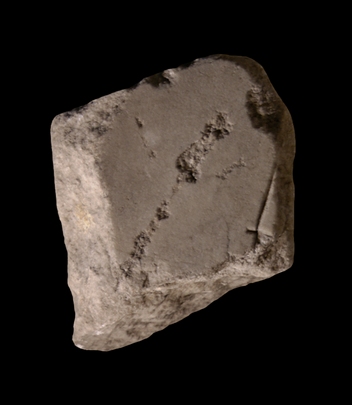
| Description A straight line follows the left edge of the fragment and stops short of reaching the other edge. It is crossed by a short bar at the end.
Identification: Slab V-13 Based on the quality of the marble, its smooth back, thickness, and certain traits that are characteristic of pieces from slab V-13, E. Rodríguez-Almeida was able to identify this fragment as one of a group of fragments that depicts the Tiber Island and the Tiber River in slab V-13. This slab is peculiar in that it decreases in thickness in a line from the lower left corner to the upper right. In addition, parallel veining lines in the marble caused the slab to break into pieces with straight, parallel sides (Rodríguez-Almeida 1970-71, pp. 109-112, fig. 3; AG 1980, p. 116, pl. 24).
Identification: Insula Tiberina This fragment belongs to the N edge of Tiber Island (AG 1980, p. 116). This tiny island, referred to as insula Tiberina, insula Tiberis, isula Tiberini, insula Aesculapi, or simply insula (part of one of these labels is visible in fr. 32a) had a nodal role in Rome's earliest history, when it was the only point at which the treacherous Tiber could be crossed by a ferry (LTUR III, p. 99). Nevertheless, the island is not mentioned in ancient sources until the 3rd c. BCE, when it became the site of the imported cult of Aesculapius. Its use as a center of healing continued through the Middle Ages to this day. Even before the 1st c. BCE the island was surrounded by stone foundations to give it the shape of a ship. Remains of the "stern" are still visible on the SE tip. Systematic construction on the island, which was located in the 14th Augustan region, seems to have begun in the 1st c. BCE with the rebuilding of the Temple of Aesculapius and the construction of the two stone bridges, the Fabricius (62 BCE) and the Cestius (mid-1st c. BCE), on either side (LTUR III, p. 100). The feature visible in this fragment may be the edge of a breakwater or a ramp constructed along the outer foundations of the island on its N side, perhaps similar to the ramp on the S side that is visible in fr. 32cde.
Identification: Tiberis E. Rodríguez-Almeida's ability to locate this fragment near the cluster of fragments that consists of frs. 32cde, 32f, and the missing 32b, demonstrates that the blank area to the right of the straight line in this fragment represents the Tiber (AG 1980, p. 116, pl. 24). Italy's third longest river, the Tiber winds its way through Rome about 25 km before it drains into the Tyrrhenian Sea. In antiquity, only Tiber Island and perhaps eight bridges interrupted its 5.6 km long stretch between the Aurelian Walls (see LTUR V, fig. 46). For the Romans, the Tiberis (other appellations were Albula, Thybris and Tiberinus) was a provider of both bounty and frustration. It was the vital trade route between the city and the outside world; fishing in its waters provided food; and until the construction of Rome's aqueducts it was the major source of drinking water. However, the Romans struggled endlessly to keep the waterway navigable and to control the violent and frequent floods. Commercial buildings such as horrea were constructed along its banks as early as the 2nd c. BCE., and later the villas, horti, and mausolea of the upper class vied for space along the river with the apartments and cemetaries of the less fortunate (LTUR V, pp. 69-73). Remains of these buildings, especially of the commercial structures and the cemetaries and residences of the poorer classes, were largely destroyed when retaining walls were constructed on both sides of the river at the end of the 19th c. (It was during the construction of the Tiber embankment along the Via Giulia in 1888 or 1898 that a plethora of FUR fragments was discovered.) The appearance of these non-monumental structures on the Marble Plan is therefore of great importance.
Despite its important role in Rome's economy and social and political history, the Tiber is not outlined on the Marble Plan. It appears simply as a blank space whose shape is discernible only through the construction that frames it on both sides (see for example fr. 24d). Although color was used to highlight certain buildings and streets on the Plan, there is so far no evidence to show that the river was emphasized in any way (except a possible label, Tiberis, inscribed in fr. 200b [Rodríguez-Almeida 1992, pp. 59-60]).
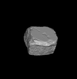
Significance Considering the many blank areas on the Marble Plan (representing gardens, arenas, temple precincts, courtyards, or areas near the edges of the Map, in addition to the Tiber) and given the fact that about 36 percent of the surviving FUR fragments are blank, it is an astonishing feat for E. Rodríguez-Almeida to have identified this fragment. He was able to do so partially from observing the quality of the marble, its thickness, smooth back, and partially because the fragment was broken along parallel lines, characteristic of pieces belonging to slab V-13 (AG 1980, pp. 115-118 and pl. 24). In the future, 3D digital matching may help attach other blank fragments to the identified areas of the Plan.
|