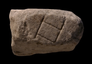
| Description The corner of a rectangular feature, divided into two compartments, appears within an open space.
Identification: Tiberis In 1970, E. Rodríguez-Almeida joined this and fr. 627 (now 621e) to the larger group 621abcd (Rodríguez-Almeida 1970-71, pp. 112-113, fig. 4). Based on similar characteristics of the marble, thickness, ductus, and the parallel breaks of this fragment, he added the whole group to slab V-13 which is mainly occupied by the Tiber river. The inscription AEMILI[---] in fr. 621abcd he suggested was a label for the pons Aemilius (Rodríguez-Almeida 1970-71, p. 113; AG 1980, pp. 115-118). The blank area in this fragment is then the Tiber and the rectangular feature, part of which appears in fr. 621e, may represent a mole in the water (AG 1980, p. 118). Despite the convincing argument, the group is not added to Rodríguez-Almeida's final drawing of the Plan in AG 1980, pl. 62.
Italy's third longest river, the Tiber winds its way through Rome about 25 km before it drains into the Tyrrhenian Sea. In antiquity, only Tiber Island and perhaps eight bridges interrupted its 5.6 km long stretch between the Aurelian Walls (see LTUR V, fig. 46). For the Romans, the Tiberis (other appellations were Albula, Thybris and Tiberinus) was a provider of both bounty and frustration. It was the vital trade route between the city and the outside world; fishing in its waters provided food; and until the construction of Rome's aqueducts it was the major source of drinking water. However, the Romans struggled endlessly to keep the waterway navigable and to control the violent and frequent floods. Commercial buildings such as horrea were constructed along its banks as early as the 2nd c. BCE., and later the villas, horti, and mausolea of the upper class vied for space along the river with the apartments and cemeteries of the less fortunate (LTUR V, pp. 69-73). Remains of these buildings, especially of the commercial structures and the cemeteries and residences of the poorer classes, were largely destroyed when retaining walls were constructed on both sides of the river at the end of the 19th c. (It was during the construction of the Tiber embankment along the Via Giulia in 1888 or 1898 that a plethora of FUR fragments was discovered.) The appearance of these non-monumental structures on the Marble Plan is therefore of great importance.
Despite its important role in Rome's economy and social and political history, the Tiber is not outlined on the Marble Plan. It appears simply as a blank space whose shape is discernible only through the construction that frames it on both sides (see for example fr. 24d). Although color was used to highlight certain buildings and streets on the Plan, there is so far no evidence to show that the river was emphasized in any way (except a possible label, Tiberis, inscribed in fr. 200b [Rodríguez-Almeida 1992, pp. 59-60]).
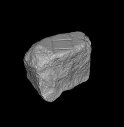
Significance Considering the many blank areas on the Marble Plan (representing gardens, arenas, temple precincts, courtyards, or areas near the edges of the Map, in addition to the Tiber) and given the fact that about 36 percent of the surviving FUR fragments are blank, it is an astonishing feat for E. Rodríguez-Almeida to have identified this fragment. He was able to do so partially from observing the quality of the marble, its thickness, smooth back, and partially because the fragment was broken along parallel lines, characteristic of pieces belonging to slab V-13. In the future, 3D digital matching may help attach other blank fragments to the identified areas of the Plan.
|