Stanford Digital Forma Urbis Romae Project
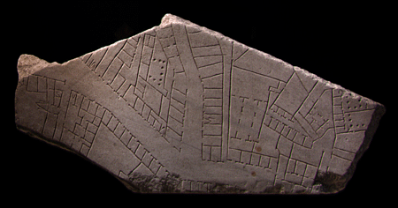
Fragment 10g shows part of the Subura, a notorious neighborhood of
imperial Rome.
It includes a major street, the Clivus Suburanus, as well as alleys, streetfront shops,
apartment buildings, courtyards, possible commercial and industrial spaces, a
neighborhood bathing establishment and a possible brothel.
|
|
|
Welcome
This site is dedicated to exploring the Forma Urbis Romae, or Severan
Marble Plan of Rome. This enormous map, measuring ca. 18.10 x 13 meters (ca. 60 x 43 feet), was carved
between 203-211 CE and
covered an entire wall inside the Templum Pacis in Rome. It depicted the groundplan of every architectural
feature in the ancient city, from large public monuments to small shops, rooms, and even staircases.
For more information about the map itself, go to
the Map page.
The Severan Marble Plan is a key resource for the study of ancient Rome, but only 10-15% of the
map survives, broken into 1,186 pieces. For centuries, scholars have tried to match the
fragments and reconstruct this great puzzle, but progress is slow--the marble pieces are heavy,
unwieldy, and not easily accessible.
Now, computer scientists and archaeologists at Stanford are employing digital technologies to try to
reconstruct the map. In collaboration with the Sovraintendenza of the Comune di Roma, a team from Stanford's
Computer Graphics laboratory has been creating digital photographs and 3D models of all 1,186 fragments.
The next step is to develop 3D matching algorithms to "solve the map," and to build
a fully searchable database
of the fragments--a much-needed tool for archaeological research. To read about our
aims and methods
in detail,
go to the Project page.
To know who is involved, click on
People.
This site presents 1,186 of the surviving fragments and 87 fragments
known only from Renaissance drawings in a fully searchable database. Each entry includes digital
color photographs and 3D models (download our
viewer, for Windows PCs only), a search box, a
description of the fragment, an analysis of its significance and a
review of the scholarly literature.
Our aim is to make this material accessible to specialists, students and the general public. The project
is a joint effort between computer scientists from the Department of Computer Science, archaeologists from the
Department of Classics at Stanford, and the Sovraintendenza of the City of Rome. We are still
developing this site; please contact us with your comments through the
People page.
The text and images contained in these web pages are protected by copyright law. Please
refer to the copyright notice for more information.
This project has been sponsored by the National Science Foundation
under the name Solving the Puzzle of the
Forma Urbis Romae.
Some of the early work was
funded under an NSF Digital Libraries Initiative
pilot grant called Creating Digital
Archives of 3D Artworks. Additional funding has been provided by
Stanford University's President's Fund,
Program on Urban Studies, and UPS Endowment Fund, Interval Research Corporation,
The Paul G. Allen Foundation for the Arts,
The Mellon Foundation, The City of Rome, and Pierluigi Zappacosta.
Copyright © 2002-2025 The Stanford Digital Forma Urbis Romae Project