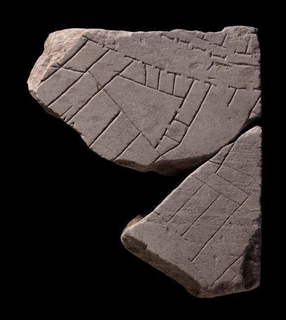
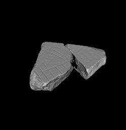
| Description These fragments were part of a slab edge. A street runs across the upper right corner of the larger piece, fragment a. It is flanked along the top by a series of small rooms behind an arcaded sidewalk. Another street is visible along the lower left edge of fr. b. A series of elongated rooms open onto it. In the triangular area between the back wall of these long rooms and the street above, an almost triangular courtyard or hall is visible to the left. It is flanked on the right by two small and one long room that all open onto it; along the top, it is faced by four small rooms that also face the street above. To the right of the triangular hall, a rectangular open space is visible, closed on three sides but with two doorways opening onto the street above.
Identification: Subura Rodriguez-Almeida (1970-71, pp. 124-27) placed these fragments along the right edge of slab VIII-2, adjoining fr.
10abcde along the left edge of slab VIII-3, which depicts a section of the Subura. One reason was the similarity of the way the lines were carved (the ductus) in these fragments and those in slab VIII-3. Another was the absence of any clamp holes on either of the slab edges or on the wall itself at this point. The most decisive point was the continuity of the streets and architecture portrayed. For example, the arcade along the upper street in this fragment is rendered by somewhat uneven dashes, just like the arcade on fr. 10abcde.
In addition, the depiction of buildings with small tabernae opening onto the street and large, irregularly-shaped, open spaces behind is similar on all these fragments. The triangular hall in this fragment has limited access from the upper street, suggesting a semiprivate function. The space may have been reserved for the owners of the shops that back onto it, or it perhaps served as a meeting hall for one of Rome's many collegia.
Archaeological and epigraphical evidence, in conjunction with the names of Medieval churches and quotes from Martial, locates the residential and commercial district called the Subura. It began near the Argiletum and the Roman forum, and from there stretched, at least in imperial times, northward up the valley between the Quirinal and Viminal Hills and eastward between the Oppian and Cispian Hills, where it probably reached as far as the Esquiline Gate (LTUR IV, p. 379). An inscription (CIL 6.9526) indicates that in the imperial period the area was divided into two sections: the Subura maior and the Subura minor. The greater Subura has been identified with the largely commercial area near the Forum Romanum, between the Viminal and the Oppian Hills, and the lesser Subura with the upper section between the Cispian and Oppian Hills, where the major thoroughfare of the Subura, the clivus Suburanus, ascended towards the Esquiline Gate (LTUR IV, p. 380).
Roman poets like Martial and Juvenal described the Subura as a sordid commercial area, riddled with violence, brothels, and collapsing buildings. In reality, it was probably not different from any other neighborhood in Rome where commercial activity intermingled with the religious and political life in the great public monuments and smaller local shrines and scholae, and where the large domus of the rich stood next to the decrepit apartment buildings that housed the poor. An abundance of evidence demonstrates that even in imperial times the Subura housed senators (probably on the upper slopes) as well as sandal makers, blacksmiths, and cloth sellers. Commercial activity was probably concentrated all along the clivus Suburanus. The many epigraphic references to the synagogue in the Subura, probably located in the Subura minor near the Esquiline Gate, suggest it was the center for the largest Jewish congregation in Rome (LTUR IV, pp. 382-383).
Identification: Vicus Sabuci The street that runs across the top of this fragment and which continues to the right onto fr.
10abcde,
curving gently and maintaining the upper arcaded sidewalk until fr. 10d, has been identified as the vicus Sabuci (Rodriguez-Almeida 1970-71, pp. 124-27). This street is attested in an inscription found in the 18th c. in the Via Merulana near S. Martino ai Monti and dedicated to Vulcan by the magistri vici Sabuci (CIL 6.801). Assuming the inscription was found at or near its original location, there is only one candidate, as the names of all the other streets in the neighborhood are known. That is the one that makes its way northeast from the Baths of Trajan to the Esquiline Gate, and sections of which are visible in this fragment and in frs.
10abcde, 10lm, and
10n.
Just beyond the upper left corner of this fragment group, the street joined the clivus Suburanus, visible on frs.
10g,
11c and
11a,
at the Esquiline Gate in the republican city walls. This acute junction of the two streets just off the fragment probably determined the triangular shape of the courtyard at the center of the upper fragment here (Rodriguez-Almeida 1970-71, pp. 125-27).
Identification: Clivus Suburanus The street that barely touches the lower left edge of these fragments has been identified as the clivus Suburanus, a major thoroughfare which passed in front of the Porticus Liviae and led to the Esquiline Gate (PM 1960, p. 70; AG 1980, pp. 78-79, pl. 7). E. Rodriguez-Almeida has suggested that the last incline of the street, the alta semita clivi Suburani mentioned in Martial 5.22, was located near the Piazza S. Martino ai Monti and that, consequently, the section of the street between the lacus Orphei and the Esquiline Gate was called vicus portae Esquilinae or some other name (LTUR I, p. 287). This name, however, is not corroborated by literary evidence; besides, CIL 531 places a Jewish synagogue near the Esquiline Gate and confirms that this area was still part of the Subura (LTUR IV, p. 379). Other sections of the clivus Suburanus are visible on frs. 10g, 11c and 11a. Ancient sources testify that the street was lined with the shops of sandal makers and book sellers (LTUR I, p. 287), adding color and detail to our understanding of these otherwise undifferentiated tabernae.
Significance The fragment is key to reconstructing the E course of one of Rome's major arteries: the clivus Suburanus. In the republican period, this street must have been the main thoroughfare between the Roman forum and the Esquiline Gate. It is thus not surprising to find it lined with large tabenae as in this fragment, even in the imperial period: a location on this street would have provided shop owners and artisans with optimal exposure and thus business. |