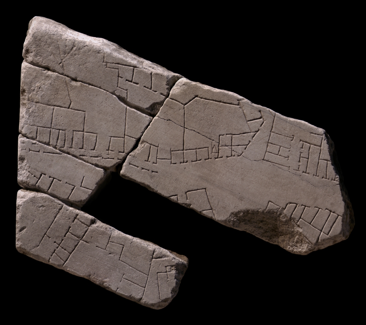
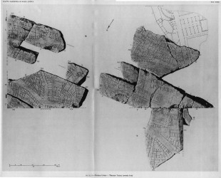
| Description Four of the five fragments in this group were part of a slab edge. A gradually widening street undulates across the pieces from left to right. An arcaded side walk flanks its upper side from the left edge to the center of the group but then stops. In the upper left corner and center, five large buildings or open spaces of irregular shape, all fronted by shops, face the horizontal street. Three small rooms are visible in the rear of one of these structures or enclosures. In the upper right corner, a vertical street joins the horizontal street and separates a rectangular building from the irregular structures to the left. This building consists of a central corridor, accessed from the horizontal street, that leads to a larger hall in the back. Five rooms open onto this corridor. The corner of another building, fronted by tabernae and with a possible staircase leading to a second floor, is visible immediately to the right of the rectangular structure. Below the horizontal street, two vertical alleys or side streets separate the structures there into three building complexes. The one to the left consists of a large room or enclosure with smaller tabernae in front, that face the horizontal street. The central building is a confusing complex of rooms of varying sizes and shapes. Only the row of shops that faces the alley on the left is regularly spaced. Of the rightmost building, only the upper left corner is visible; it seems to have two tabernae in front, a door leading to a larger space behind them, and a few other rooms with invisible access routes.
Identification: Subura The location of these fragments along the left edge of slab VIII-3 identifies them as a section of the Subura (PM 1960, p. 70, fig. p. 68; AG 1980, pl. 7). Archaeological and epigraphical evidence, in conjunction with the names of Medieval churches and quotes from Martial, locates the residential and commercial district called the Subura. It began near the Argiletum and the Roman forum, and from there stretched, at least in imperial times, northward up the valley between the Quirinal and Viminal Hills and eastward between the Oppian and Cispian Hills, where it probably reached as far as the Esquiline Gate (LTUR IV, p. 379). An inscription (CIL 6.9526) indicates that in the imperial period the area was divided into two sections: the Subura maior and the Subura minor. The greater Subura has been identified with the largely commercial area near the Forum Romanum, between the Viminal and the Oppian Hills, and the lesser Subura with the upper section between the Cispian and Oppian Hills, where the major thoroughfare of the Subura, the clivus Suburanus, ascended towards the Esquiline Gate (LTUR IV, p. 380). The section depicted here was probably close to the gardens of Maecenas, the horti Maecenatis (see LTUR III, fig. 42).
Roman poets like Martial and Juvenal described the Subura as a sordid commercial area, riddled with violence, brothels, and collapsing buildings. In reality, it was probably not different from any other neighborhood in Rome where commercial activity intermingled with the religious and political life in the great public monuments and smaller local shrines and the meeting rooms of the local collegia, and where the large domus of the rich stood next to the decrepit apartment buildings that housed the poor. An abundance of evidence demonstrates that even in imperial times the Subura housed senators (probably on the upper slopes) as well as sandal makers, blacksmiths, and cloth sellers. Commercial activity was probably concentrated all along the clivus Suburanus. The many epigraphic references to the synagogue in the Subura, probably located in the Subura minor near the Esquiline Gate, suggest it was the center for the largest Jewish congregation in Rome (LTUR IV, pp. 382-383). The large, irregular spaces in the upper left and center of these fragments may have been work areas, perhaps open to the sky, with small shops in front. The three small rooms in the back of one of the large irregular spaces perhaps served as living quarters for the shop owners.
Identification: Vicus Sabuci The horizontal street that traverses these five fragments is also visible in frs.
10Abc , 10lm, and
10n. It has been identified as the vicus Sabuci, a street that makes its way northeast from the Baths of Trajan to the Esquiline Gate (Rodriguez-Almeida 1970-71, pp. 124-27). The name of the street is attested in an inscription that was found in the 18th c. in the Via Merulana near S. Martino ai Monti and which was dedicated to Vulcan by the magistri vici Sabuci (CIL 6.801). Assuming the inscription was found at or near its original location, this street is the only candidate, as the names of all the other streets in the neighborhood are known.
Just beyond the upper left corner of fr. 10Aab, the vicus Sabuci joined the clivus Suburanus, visible on frs.
10g,
11c and
11a,
at the Esquiline Gate in the republican city walls (Rodriguez-Almeida 1970-71, pp. 125-27). The two vertical alleys in this fragment may join the vicus Sabuci with the clivus Suburanus. In fact, the street or alley that separates the two structures in the lower right corner of these fragments probably becomes the vertical street visible in the center of fr. 10g.
Identification: Horti Maecenatis (?) It has been suggested that the vicus Sabuci (see above) formed the N boundary to the Gardens of Maecenas (LTUR III, p. 72). This theory is strengthened by the discovery of remains of a circular structure near the entrance to the Brancaccio gardens, exactly where it appears on FUR fr. 10v (Rodríguez-Almeida 1975-76, p. 278; LTUR III, p. 72). The circular structure has tentatively been identified with Rome's first warm water swimming pool, which Maecenas is known to have constructed ([Cass. Dio 55.7] Rodríguez-Almeida 1975-76, p. 278). If this interpretation is correct, the area south of the "pool" and of the vicus Sabuci originally must have been part of the Gardens of Maecenas. The area south of the vicus Sabuci in these fragments was probably also a part of the gardens, and the architecture that lines the S side of the street is most likely post-Neronian construction that gradually encroached upon the N boundary of the original horti after Maecenas' death. This theory might explain why the architecture on the S side of the street is more open and regular than that on the N side, and why only the S southwalk is covered with an portico. Not much is known about the gardens. Their creation was perhaps made possible by the reorganization of Rome's water supply in 33 BCE by Augustus and Agrippa. Maecenas had a domus within the gardens, and he bequeathed the entire estate to Augustus after his death (LTUR III, pp. 71-73). The original extent of the gardens is still debated (see LTUR III, pp. 71-73, for a summary of the many theories regarding the boundaries and fig. 42 for a map of the area).
Significance Rodriguez-Almeida's identification of the street in these fragments, and in frs. 10Aab and 10lm and 10n, as the vicus Sabuci is key to our knowledge about the course of this street, otherwise only known from an inscription. The diversity of commercial architecture depicted here, such as small tabernae and large work areas, lends credibility to the descriptions of poets like Martial and Juvenal who characterized the Subura neighborhood as predominantly commercial. If the identification of the area S of the vicus Sabuci as having formerly been part of the Gardens of Maecenas is correct, then these fragments offer a rare insight into the gradual encroachment of city architecture upon a luxurious, private garden in the early Empire. |