ID AND LOCATION
| Stanford #
| 11i |
| AG1980 #
| 11i |
| PM1960 #
| 570 |
| Slab #
| VII-7 |
| Adjoins
| 11fgh |
CONDITION
| Located
| true |
| Incised
| true |
| Surviving
| true |
| Subfragments
| 1 |
| Plaster Parts
| 0 |
| Back Surface
| smooth |
| Slab Edges
| 1 |
| Clamp Holes
| 1 |
| Tassello
| no |
TECHNICAL INFO
|
|
|
|
|
|
|
|
|
|
|
| ANALYSIS
|
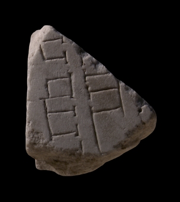
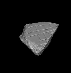
| Description The fragment was part of a slab edge. A partial clamp hole is visible along the side. A narrow street or alley traverses the piece vertically. It is flanked on both sides by tabernae. The shops on the left seen to front an open space, perhaps a courtyard. Behind the tabernae on the right a section of a colonnade is visible.
Identification: Alley off the vicus Patricius. In 1968, L. Cozza was able to join this fragment to the upper left side of the large fragment group 11fgh (Cozza 1968, p. 22). E. Rodríguez-Almeida later located this entire group, including the joining fr. 11i, in the bottom left corner of slab VII-7, based on the similarities such as marble color, thickness, smooth back, and sawing irregularities between these fragments and those already securely placed in the top of the slab (Rodríguez-Almeida 1975-76, pp. 274-75, and fig. 8; 1992, pp. 66-68, figs. 15-16). In addition to these similarities, certain features, such as the horizontal street and the porticoed structure in fr. 11fgh, correspond exactly to excavated remains between the Viminal and Cispian Hills (see Rodríguez-Almeida 1975-76, fig. 8). The horizontal street in that fragment can therefore be identified as the vicus Patricius, the street that marked the border between the fourth and the sixth Augustan regions of the city (Rodríguez-Almeida 1975-76, p. 274; LTUR V, p. 183). The vicus Patricius started at the clivus Suburanus in the south and ran north between the Cispian and Viminal Hills to the Viminal Gate in the Republican city walls (corresponding to modern Via Urbana; see map in LTUR III, fig. 190). The alley in this fragment is perpendicular to the vicus Patricius and must have connected to it right at the breaking point between this and fr. 11h. Since the vicus Patricius practically divided the Viminal and the Cispian Hills, the section shown in this fragment must be located at the foot of the Cispian Hill.
Significance Rodríguez-Almeida's positioning of this and the joining fragment group provides us with a vivid picture of a little-known, non-monumental neighborhood that seems to have been a mix of multi-storey apartment complexes, luxurious single-family residences, shops with courtyards (fr. 11e), of an elaborate public garden(?), a warehouse or a market, and perhaps the headquarters of a professional or religious organization (fr. 11fgh).
|
|
| HISTORY OF FRAGMENT |
| Like the majority of FUR fragments, this piece was discovered in 1562 in a garden behind the Church of Saints Cosmas and Damian. From here, it was transferred to the Palazzo Farnese and stored there. The fragment was later used as building material in the 17th-c. construction of the Farnese family's Giardino Segreto (Secret Garden) near the Via Giulia, and was rediscovered in 1888 or 1898 when the walls of the garden were demolished. Since then, it has been stored with the other known FUR fragments in various places: the storerooms of the Commissione Archeologica (1888/1898-1903), the Antiquarium Comunale (1924-1939), the Capitoline Museums (1939-1955), the Palazzo Braschi (1955-1998), and since 1998 in the Museo della Civiltà Romana in EUR under the auspices of the Sovraintendenza ai Beni Culturali del Comune di Roma. (This fragment's history corresponds to Iter E'' as summarized in PM 1960, p. 56.) N.B. PM 1960 does not reveal the whereabouts of the fragment between 1903 and 1924.
Text by Tina Najbjerg |
|
| KEYWORDS
|
| alley, tabernae, courtyard, colonnade |
|