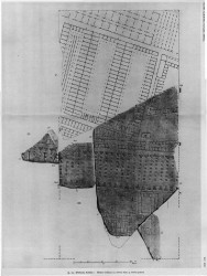
| Description The bottom of this fragment is part of this slab's lower edge. At the top of the fragment lies a horizontal row of tabernae, two with internal staircases. The tabernae face a large open space below, in the center of which two square structures, each divided into three rooms, are visible.
Identification: Tiberis The fact that this fragment attaches to fr. 24c identifies it as part of the riverfront structures between the porticus Aemilia and the Tiber. The square buildings are perhaps storage areas. The blank area below them represents a section of the Tiber. Italy's third longest river, the Tiber winds its way through Rome about 25 km before it drains into the Tyrrhenian Sea. In antiquity, only Tiber Island and perhaps eight bridges interrupted its 5.6 km long stretch between the Aurelian Walls (see LTUR V, fig. 46). For the Romans, the Tiberis (other appellations were Albula, Thybris and Tiberinus) was a provider of both bounty and frustration. It was the vital trade route between the city and the outside world; fishing in its waters provided food; and until the construction of Rome's aqueducts it was the major source of drinking water. However, the Romans struggled endlessly to keep the waterway navigable and to control the violent and frequent floods. Commercial buildings such as horrea were constructed along its banks as early as the 2nd c. BCE., and later the villas, horti, and mausolea of the upper class vied for space along the river with the apartments and cemetaries of the less fortunate (LTUR V, pp. 69-73). Remains of these buildings, especially of the commercial structures and the cemetaries and residences of the poorer classes, were largely destroyed when retaining walls were constructed on both sides of the river at the end of the 19th c. (It was during the construction of the Tiber embankment along the Via Giulia in 1888 or 1898 that a plethora of FUR fragments was discovered.) The appearance of these non-monumental structures on the Marble Plan is therefore of great importance.
Despite its important role in Rome's economy and social and political history, the Tiber is not outlined on the Marble Plan. It appears simply as a blank space whose shape is discernible only through the construction that frames it on both sides, as witnessed by this fragment. Although color was used to highlight certain buildings and streets on the Plan, there is so far no evidence to show that the river was emphasized in any way (except a possible label, Tiberis, in fr. 200b [Rodríguez-Almeida 1992, pp. 59-60]).
Significance A curious element of the Plan is the lack of outlines for geographical or political areas. The Tiber, for example, is not outlined here or in any of the other fragments that include it; it is only visible through a lack of architecture. This fragment, then, illustrates the way in which Plan was graphically conceived: the map only showed architecture and built elements, while geographical element such as rivers, gardens, or open areas were simply left blank. This, of course, means that many of the fragments of the Plan are blank and thus impossible to identify. |
