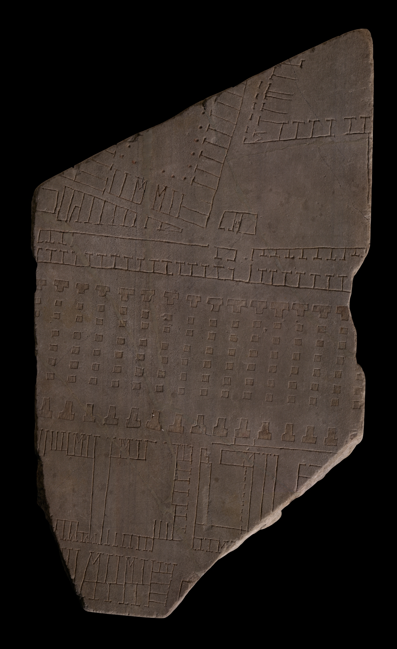
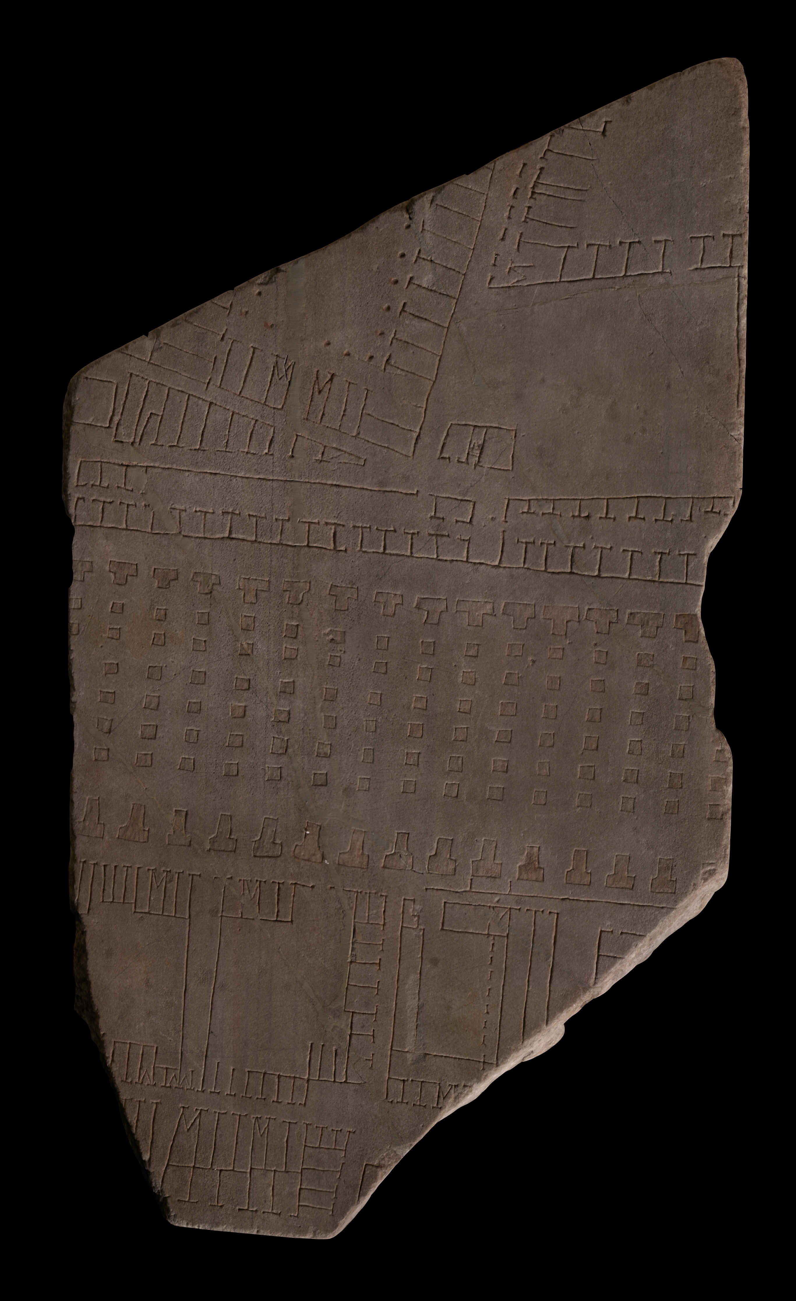
| Description This huge fragment includes much of the right edge of a slab. Three clamp holes are visible along the right side and a wedge mark (tassello) can be seen on the left side. Two veining lines run parallel to the edges of the slab (see AG 1980, pl, 16). The bottom tip of the piece has been sawed off - this was probably done in 1742 when other FUR fragments suffered the same treatment before being fitted into large wooden frames for exhibition in the Capitoline museums. The center of the fragment is dominated by a large, horizontal structure that traverses the entire piece. Both front and back of the building consists of a line of T-shaped piers, those at the bottom being slightly longer than those at top. Between each T-shaped pier lies a row of seven square piers. The space between the bottom row of square and T-shaped piers is deeper than at top. This building is separated from three smaller structures below it by a street. The two on the left consist of open spaces surrounded by outward-facing tabernae or rooms of varying lengths and widths. The building to the right is separated from the piered structure by a long wall or step. The central space of this rightmost structure is flanked on three sides by elongated rooms, an arcade, and, at the bottom, by a row of shops. Staircases suggest that all these three buildings were two-storeyed. They are separated from a rectangular cluster of back-to-back tabernae and below, by a narrow street. Additional structures are barely visible on either side of this cluster.
Above and parallel to the piered structure are two long, horizontal rows of tabernae that face each other. In one section, the individual walls of the shops are missing - probably a mistake by the engraver? One, perhaps two openings allow passage through the long rows.
The top third of the fragment shows two large buildings, parallel to each other but at an angle to the piered structure below. The building on the left consists of an open space surrounded by inward-facing rooms and a colonnade. Two staircases frame the central entry into this complex at the bottom. The triangular space created by the odd angle of this building in relation to the long, horizontal rows of tabernae below is occupied by a row of downward facing shops. To the left of these, in a small piazza, lies a small, rectangular feature. The building in the top left corner of the fragment consists of a large open space, trapezoidal in shape, that is flanked by inward-facing rooms on the bottom and outward-facing rooms on the left. The latter are fronted by an arcade. A staircase in the bottom left corner gave access to a second storey. The main entry into the building seems to have been through a central opening in the bottom row of rooms, although some of the rooms on the left side do not have a back wall and may therefore also have provided access to the open court in center (unless this wall mistakenly was left out by the engraver). A large, rectangular piazza is situated below this building in the right side of the fragment. A small, three-roomed structure can be seen in the bottom left corner of this piazza. The room to the left is accessed from below; the room on the right does not seem to have any openings; and the narrow, central space seems to have functioned as a staircase.
All buildings on this fragment are drawn with a single line, as is usual on the Plan, except the piers and the arcaded walls of the large building in center; these are rendered in outline and recessed. Traces of minium survive in these outlined piers.
Identification: Porticus Aemilia The piered structure in the center of this fragment, more of which is visible in fragments 23 and 24b, is the porticus Aemilia (PM 1960, p. 81-82; AG 1980, p. 102). Formerly believed to represent the saepta Iulia, the structure was correctly identified by G. Gatti on basis of the inscription in fr. 23 and on his comparison of the architecture depicted here with the archaeological remains discovered between the Tiber and the Aventine Hill (Gatti 1934, pl. 2. See also LTUR IV, fig. 44). This interpretation is generally accepted now, with a few exceptions (see Richardson 1992, p. 143, and Tuck 2000).
The porticus Aemilia was constructed in 193 BCE by the aediles M. Aemilius Lepidus and M. Aemilius Paullus (Livy 35.10.12) and restored in 174 BCE by the censors Q. Fulvius Flaccus and A. Postumius Albinus (Livy 41.27.8) - probably as part of the large complex of warehouses and markets by the Tiber called the Emporium (LTUR IV, pp. 116-17). The present remains of the porticus Aemilia, stretching between Via B. Franklin and the Via Marmorata, between the Via G. Branca and the Via A. Vespucci, demonstrate that the gargantuan building measured 487 m. in length and 90 m. in width (LTUR IV, p. 117). It was constructed as a wide staircase on the downward gradient towards the Tiber, parallel to the river (Gatti's division of the structure into four wide steps is not indicated on the Marble Plan). Walls that ran perpendicular to the long front and back walls and that were pierced by arched openings divided the building into 50 spaces; each space was covered by a barrel vault and backed and fronted by an arched opening in the long outer walls (see reconstruction in Gatti 1934, pl. 4 or LTUR IV, fig. 45). The function of the building is uncertain. Unless the many openings were separated by wooden partitions, it is unlikely to have served as a warehouse. Its architecture does not conform to what we normally associate with a porticus, which is a large, open space surrounded on three or four sides by covered colonnades. Why this utilitarian building was highlighted on the Plan with rendering in outline and recessed areas, a technique usually reserved for temples (Reynolds 1996, pp. 74-77) and important public monuments, is also uncertain.
Identification: Praedia et horrea Galbana The large structures visible in the upper section of this fragment were part of a large imperial estate, the praedia Galbae or Galbana (PM 1960, pp. 81-82; AG 1980, pp. 102-105). Originally belonging to the family of Servius Sulpicius Galba, probably the praetor of 187 BCE, the private estate later became imperial property, most likely during the reign of Galba (LTUR III, p. 40). The proximity of a funerary monument (see below) to a later family member of the same name, perhaps the consul of 144 BCE (Ferrea 1998) or of 108 BCE (F. Coarelli, LTUR III, p. 42) confirms the identity of the Republican property, which may at an earlier state have been called the praedia Sulpicia and have incorporated the horrea Sulpicia, mentioned by Horace (Carm. 4.12.18)(LTUR II, p. 40). Archaeological evidence recorded by Lanciani and FUR fragments 24a (missing), 24c, and, as suggested by E. Rodríguez-Almeida (1977-1978, pp. 18-21, figs. 3, 5), frs. 91 and 107 demonstrate that the enormous estate at the foot of the Aventine Hill in imperial times stretched from the porticus Aemilia in the north and to an unknown area beyond the Monte Testaccio in the south (LTUR II, p. 43; Rodríguez-Almeida 1977-1978, fig. 5). The abundant epigraphical evidence suggests that the residential spaces of the imperial complex gradually yielded to large warehouses for the storage of the public grain supply, and of oil, wine, food, clothing, and marble (LTUR II, p. 41; Richardson 1992, p. 193). The mountain of discarded amphoras that constitutes the nearby Monte Testaccio is a testimony to the large scale operation of these horrea. Inscriptions also suggest that the many warehouse workers, variously referred to as horrearii, operarii Galbenses, or Galbenses, to name a few, were organized into three cohortes, as if in the army, and that there were different collegia, or societies to which they could belong (LTUR II, p. 41). The latter implies that the complex included scholae for the meetings of these collegia, and most likely also bathing establishments, both of which are probably included in the neighboring horrea Lolliana, visible in fr. 25.
The function of the three parallel buildings visible in the top left corner of this fragment, and especially visible in the missing fr. 24a is disputed. G. Gatti suggested with some reservation that they constitute actual warehouses (PM 1960, p. 81, n.4). E. Rodríguez-Almeida, however, proposed that they served as living quarters, ergastula, for the workers and that THEY are the three cohortes mentioned in various inscriptions (Rodríguez-Almeida 1977-78, p. 20). He identified the two parallel lines in the courtyard of the easternmost structure (only visible in the missing fr. 24a) as a water basin flanked by arcades, a feature that he proposed would make more sense in a residential unit than in a warehouse. The actual warehouses he situated further south, closer to the Monte Testaccio. This interpretation is accepted by F. Coarelli (LTUR III, pp. 41-42), yet it remains somewhat problematic. First of all, warehouses are likely to be situated as close to the Tiber as possible in order to minimize the effort of carrying the goods from the river to the storage areas. Their proximity to the dumping grounds of the Monte Testaccio must be of secondary concern. Secondly, the layout of these buildings is similar to horrea depicted and labeled elsewhere on the FUR (see fr. 25a) and to actual remains in Ostia (see Staccioli 1962). Third, the restricted and easily guarded accesses to these buildings suggest they contained valuable goods rather than functioned as residences for workers. Furthermore, if the elongated channel in the leftmost building is a wash basin for the workers, as proposed by Rodríguez-Almeida, why is there not one in each of the three units? In addition, the assumption that a water source is more useful in a residential unit than in a storage area for grain is not neccessarily true. Grain, when overheated, can easily burst into flames, and it would indeed be vital to have water close at hand to extinguish a small fire before it could spread to other compartments and potentially destroy the entire public grain supply. Finally, excavations of the easternmost court show that it had raised floors, a feature not likely to be found in the living quarters of slaves but essential for creating a draft underneath areas used for grain storage, as seen in several instances in Ostia and Portus (Rickman 1971, p. 103).
The small, rectangular feature in the bottom left corner of the piazza has been identified as a neighborhood shrine (see Sartorio 1988, p. 32).
Identification: Funerary Monument of Servius Sulpicius Galba The small square structure in the top left corner of this fragment, situated between the horrea Galbana and the porticus Aemilia, is a funerary monument that was discovered during excavations on this very spot in 1885 (PM 1960, p. 81). The tomb belonged to Ser. Sulpicius Galba, who is to be identified either with the consul of 144 BCE (Ferrea 1998) or with the consul of 108 BCE (F. Coarelli, LTUR III, p. 42). Today preserved in the Antiquarium Comunale di Roma (see Ferrea 1998), the tomb is one of the few known examples of individual mausolea in Rome (LTUR IV, p. 299). It is uncertain whether the lines on this fragment represent the monument itself or the protecting wall which excavations show was placed around it in imperial times (see Ferrea 1998, fig. 3). Excavations also revealed the paved street along which the monument was placed, visible on this fragment (see Ferrea 1998, fig. 4, for Lanciani's drawing).
Identification: Tiberis The blank area that was sawed off the tip of this fragment in 1742 represented a section of the Tiber. Italy's third longest river, the Tiber winds its way through Rome about 25 km before it drains into the Tyrrhenian Sea. In antiquity, only Tiber Island and perhaps eight bridges interrupted its 5.6 km long stretch between the Aurelian Walls (see LTUR V, fig. 46). For the Romans, the Tiberis (other appellations were Albula, Thybris and Tiberinus) was a provider of both bounty and frustration. It was the vital trade route between the city and the outside world; fishing in its waters provided food; and until the construction of Rome's aqueducts it was the major source of drinking water. However, the Romans struggled endlessly to keep the waterway navigable and to control the violent and frequent floods. Commercial buildings such as horrea were constructed along its banks as early as the 2nd c. BCE., and later the villas, horti, and mausolea of the upper class vied for space along the river with the apartments and cemetaries of the less fortunate (LTUR V, pp. 69-73). Remains of these buildings, especially of the commercial structures and the cemetaries and residences of the poorer classes, were largely destroyed when retaining walls were constructed on both sides of the river at the end of the 19th c. (It was during the construction of the Tiber embankment along the Via Giulia in 1888 or 1898 that a plethora of FUR fragments was discovered.) The appearance of these non-monumental structures on the Marble Plan is therefore of great importance.
Despite its important role in Rome's economy and social and political history, the Tiber is not outlined on the Marble Plan. It appears simply as a blank space whose shape is discernible only through the construction that frames it on both sides (see for example fr. 24d). Although color was used to highlight certain buildings and streets on the Plan, there is so far no evidence to show that the river was emphasized in any way (except a possible label, Tiberis, inscribed in fr. 200b [Rodríguez-Almeida 1992, pp. 59-60]).
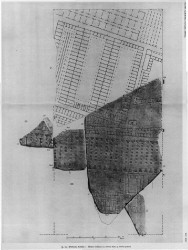
Significance FUR fragments 23, 24a, 24b, and 24c were key elements in identifying the remains of a large Republican building of opus incertum, discovered near the Tiber and south of the Aventine, as being those of the porticus Aemilia. This fragment, especially in conjunction with the lost fragment 24a (see AG 1980, pl. 16 and PM 1960, pl. 24), gives us a particularly good glimpse of the great commercial development of the riverbank and plain SW of the Aventine Hill. Enormous horrea mingle with shops and marketplaces, and give a sense of the bustling activity and movement in this area near the Tiber. |