ID AND LOCATION
| Stanford #
| 2a |
| AG1980 #
| 2a |
| PM1960 #
| 2 a |
| Slab #
| XI-10 |
| Adjoins
| 2b |
CONDITION
| Located
| true |
| Incised
| true |
| Surviving
| true |
| Subfragments
| 1 |
| Plaster Parts
| 0 |
| Back Surface
| smooth |
| Slab Edges
| 1 |
| Clamp Holes
| 0 |
| Tassello
| no |
TECHNICAL INFO
|
|
|
|
|
|
|
|
|
|
|
| ANALYSIS
|
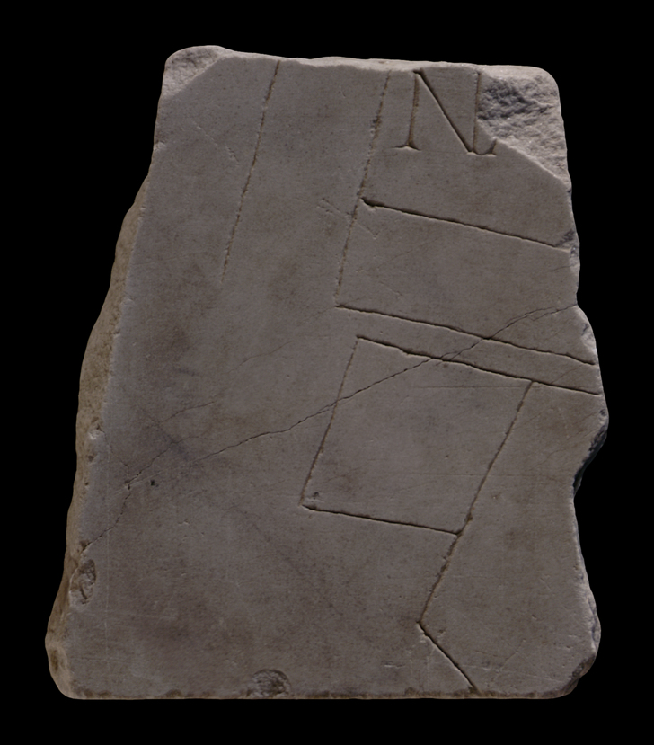
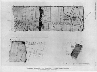
| Description The fragment was part of a slab edge. In its complete state, when it was still joined to fr. 2b, the fragment depicted a large, rectangular space in the upper right corner; here, the inscription NAVALEMFER[---] appeared. Two elongated, rectangular areas with no visible accesses bordered the bottom of this space. The opening between the two rectangles led to a parallel street below. Three adjoining structures backed onto this street; the two on the left were seemingly inaccessible and were of irregular shapes; the one on the right was flanked at top by a row of small rooms. To the left of these structures there was a wide, open space. A line that ran parallel to the left side of the large structure in the top right corner may have depicted a wall or the edge of a sidewalk.
Identification: Navale Inferius The inscription NAVALEMFER in this and in the missing fragment 2b is tentatively reconstructed as NAVALE INFERIUS (PM 1960, p. 60). According to Renaissance drawing Cod. Vat. Lat. 3439 - Fo 18r (see fr. 2b), the inscription is complete; it should be noted, however, that the edges of fragments are not always correctly rendered in the 16th-century drawings (compare for example the lower edge of fr. 4b to the corresponding Renaissance drawing as reproduced in PM 1960, pl. 7). It is thus possible that the inscription is incomplete. If the reconstruction of the label is correct, it seemingly referred to a military ship yard whose nomenclature as inferius either positioned it along the "lower" course of the Tiber or distinguished it from a "greater" yard. Since the height of the slab to which this fragment belonged can be calculated to be approximately 37 cm (i.e. similar to slab XI-6 whose height is preserved), it is generally placed in the top row of slabs, in the upper right corner of the map, as number XI-10 (PM 1960, p. 60). There are a number of problems associated with this identification and location, however: the only navalia known from literary sources is the great Republican yard, which was located along the Tiber in the Campus Martius (PM 1960, p. 60; LTUR III, p. 339). Although this yard may have gone out of use completely by the Severan period, when the map was carved, there is no evidence that a lesser (inferius) port was established along the Tiber beyond the Monte Testaccio, which is what the inscription and the location of the fragment suggest. Also problematic is the fact that this "lesser" or "lower" navalia seems to be situated somewhat far from the Tiber; plus, the buildings depicted here do not resemble a military port (Richardson 1992, p. 267). The authors of PM 1960 conclude that there is no reason to doubt the existence of a newer ship yard, called "inferius" to distinguish it from the earlier, larger port in the Campus Martius (PM 1960, p. 60). F. Coarelli disagrees (but does not offer any other explanation: LTUR III, p. 340).
Significance This fragment provides the only evidence for an unknown structure called the navale inferius that seems to have been located near the left bank of the Tiber, beyond the warehouses at the foot of the Aventine Hill. If the identification of the inscription and the location of the fragment are correct, the piece is key to our knowledge of the urban landscape in this section of Rome. |
|
| HISTORY OF FRAGMENT |
| When this piece was discovered in 1562 in a garden behind the Church of Saints Cosmas and Damian, it was part of a much larger piece (see fr. 2b). This piece was transferred to the Palazzo Farnese and stored there. Renaissance engravers reproduced it in 16th-c. drawings that are now kept in the Vatican (for more information about the creation and accuracy of these drawings, see Cod. Vat. Lat. 3439), and Giovanni Pietro Bellori included it in his 1673 publication. At some point there after, the fragment broke and only section 2a remains. In 1742, it was moved to the Capitoline Museums and exhibited with some of the other fragments in wooden frames along the main staircase. Since then, the fragment has been stored with the other known FUR fragments in various places: the storerooms of the Capitoline Museums (1903-1924), in the Antiquarium Comunale (1924-1939), the Capitoline Museums again (1939-1955), the Palazzo Braschi (1955-1998), and since 1998 in the Museo della Civiltà Romana in EUR under the auspices of the Sovraintendenza ai Beni Culturali del Comune di Roma. (This fragments history corresponds to Iter B as summarized in PM 1960, p. 56.)
Text by Tina Najbjerg
|
|
| KEYWORDS
|
| river, ship yard, war ships, Tiber, courtyard, open space, inscription, military port |
|