ID AND LOCATION
| Stanford #
| 4a |
| AG1980 #
| 4a |
| PM1960 #
| 4 a |
| Slab #
| X-5 |
| Adjoins
| 4b |
CONDITION
| Located
| true |
| Incised
| true |
| Surviving
| true |
| Subfragments
| 1 |
| Plaster Parts
| 0 |
| Back Surface
| smooth |
| Slab Edges
| 0 |
| Clamp Holes
| 0 |
| Tassello
| no |
TECHNICAL INFO
|
|
|
|
|
|
BIBLIOGRAPHY
- AG 1980, pp. 26, 63-65, pl. 2
- LTUR I: Arcus Neroniani (Z. Mari and V. Jolivet), pp. 63-65, 100-101
- PM 1960, p. 63, pls. 7, 16, 62 and drawing on p. 62
- Richardson 1992, p. 27 (Arcus Neroniani)
|
|
|
|
|
| ANALYSIS
|
| Description
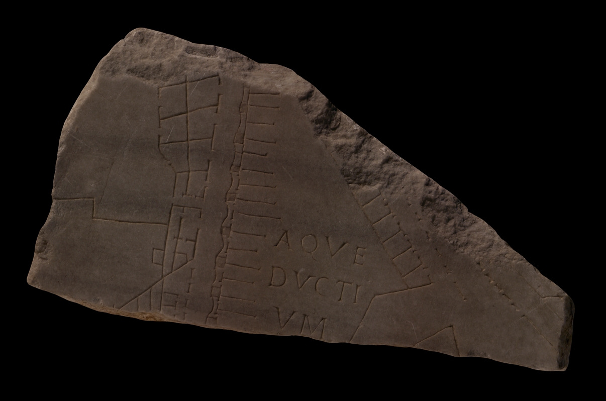
A monumental street, flanked on both sides by arcaded sidewalks, runs in an oblique angle from the top of the fragment to the lower right corner. The structures behind the arcade to the right are broken off, except for a piece of wall at lower right; this arcade becomes a wall at its lower end. Behind the left arcade is a row of tabernae. This street ends in an irregularly shaped open space at bottom right of the fragment. An angled wall separates this space from an open space at the center of the fragment. There, the inscription AQVE/DUCTI/VM labels the vertical, elongated feature that traverses the fragment. The aqueduct is depicted as a row of recessed and red-painted squares, connected on the left by concave lines, on the right by straight lines or dashes. Fifteen parallel, horizontal lines of different lengths emerge from the right side of the aqueduct. On the left, a street runs parallel to the aqueduct and separates it, at top, from a row of back-to-back tabernae?, in center, from a strange, trapezoidal structure with four small rooms, and at the bottom, by a row of tabernae fronted by an arcade. In the left side of the fragment, two large open spaces are separated by a horizontal wall with bend in the center. The top space is accessible from the back-to-back tabernae and from the vertical street by a narrow passageway. The open space in the lower left corner does not seem to be connected to the buildings along the street, unless the small, rectangular feature to the far right denotes a staircase by which the trapezoidal building can be reached. The feature lacks the parallel lines or triangles that usually denote stairs on the Marble Plan.
Identification: Arcus Neroniani
The location of this aqueduct just south of the templum Divi Claudi in the adjoining fr. 4b identifies it as a stretch of the arcus Neroniani at the foot of the Caelian Hill. This was a 2 km long offshoot of the aqua Claudia which Frontinus (Aq. 1.20, 2.76 and 87) relates ended at the Temple to Claudius (LTUR I, pp. 63-65). From there, it supplied the Caelian Hill, the Palatine, the Aventine and Trastevere. It was built under Nero after the great fire of 64 CE to supply the nymphaeum he had built along the E side of the platform designated for the Temple to Deified Claudius (but not finished as such until after Nero's reign), as well as the central lake of his Domus Aurea on the site of the later Flavian Amphitheater (Colosseum). A 16th-c. plan of Rome, the Pianta Ligorio, shows that the aqueduct ended at the Temple of Claudius in a rectangular tank subdivided into several spaces (LTUR I, p. 100), but there is no easily recognized indication of that here. The recessed squares that still show faint traces of red paint in this fragment depict the piers of the aqueduct, while the curved and the dashed lines indicate the series of arches that supported the water channel. The short, horizontal lines that emerge from the right side of the aqueduct may represent actual walls on the ground. These perhaps functioned as extra supports for the water channel, or they represented walls of rooms built up against the arched piers (G. Cressedi in PM 1960, p. 206). The representation of the Neronian aqueduct, seen from above, is strikingly different from the aqua Alsietina (see for example fr. 37Cabc), which is seen entirely in elevation view (Reynolds 1996, fig. 2.10). The arcus Neroniani was repaired several times, including in 201 CE by Septimius Severus and Caracalla (CIL 6.1259). Could this be the reason why the square piers of the structure were recessed and highlighted with red paint, a technique generally reserved for temple architecture on the FUR?
The monumental street on the right in this fragment has been partially excavated underneath the Via di San Paolo della Croce which follows the course of the ancient road. Near the SW corner of the platform of the Temple of Claudius the street split in two, and the right fork flanked the W edge of the temple platform (see PM 1960, p. 62).
Significance The difference between the representation of the aqueduct in this fragment and the aqua Alsietina demonstrates that the engravers sometimes employed ad hoc solutions when depicting the topography of the Marble Plan: while the Neronian channel ran through dense urban space and is seen from above, as is common for architecture on the FUR, long stretches of the Alsietina crossed open spaces and there was thus room to depict it in elevation view and make it instantly recognisable as an aqueduct (AG 1980, pp. 144-45; Reynolds 1996, pp. 67-69).
The stream-lined architecture on the left side of the aqueduct seems to have been adapted to the course of the water channel. It is strikingly different from the architecture in the adjoining fragment 4b which offers a jumble of strange, angular features. The incline of the Caelian Hill may account for the difference. |
|
| HISTORY OF FRAGMENT |
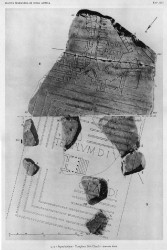
| Like the majority of the FUR fragments, this piece was discovered in 1562 in the garden behind the Church of Saints Cosmas and Damian. From here, it was transferred to the Palazzo Farnese and stored there. Renaissance engravers reproduced the fragment in 16th c. drawings that are now kept in the Vatican (Cod. Vat. Lat. 3439), and Giovanni Pietro Bellori included it in his 1673 publication of the FUR. In 1742, it was moved to the Capitoline Museums and exhibited with the other known fragments in wooden frames along the main staircase. In 1903, museum curators included the piece in a reconstruction of the FUR mounted on a wall behind the Palazzo dei Conservatori (1903-1924). Since then, the fragment has been stored with the other known FUR fragments in various places: the storerooms of the Antiquarium Comunale (1924-1939), the Capitoline Museums again (1939-1955), the Palazzo Braschi (1955-1998), and, since 1998, in the Museo della Civiltà Romana in EUR under the auspices of the Sovraintendenza ai Beni Culturali del Comune di Roma. (This fragments history corresponds to Iter A as summarized in PM 1960, p. 56.)
Text by Tina Najbjerg and Jennifer Trimble
|
|
| KEYWORDS
|
| aqueduct, square piers, tabernae, arcaded sidewalks, stairs, shops, street, open spaces, |
|