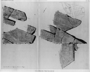
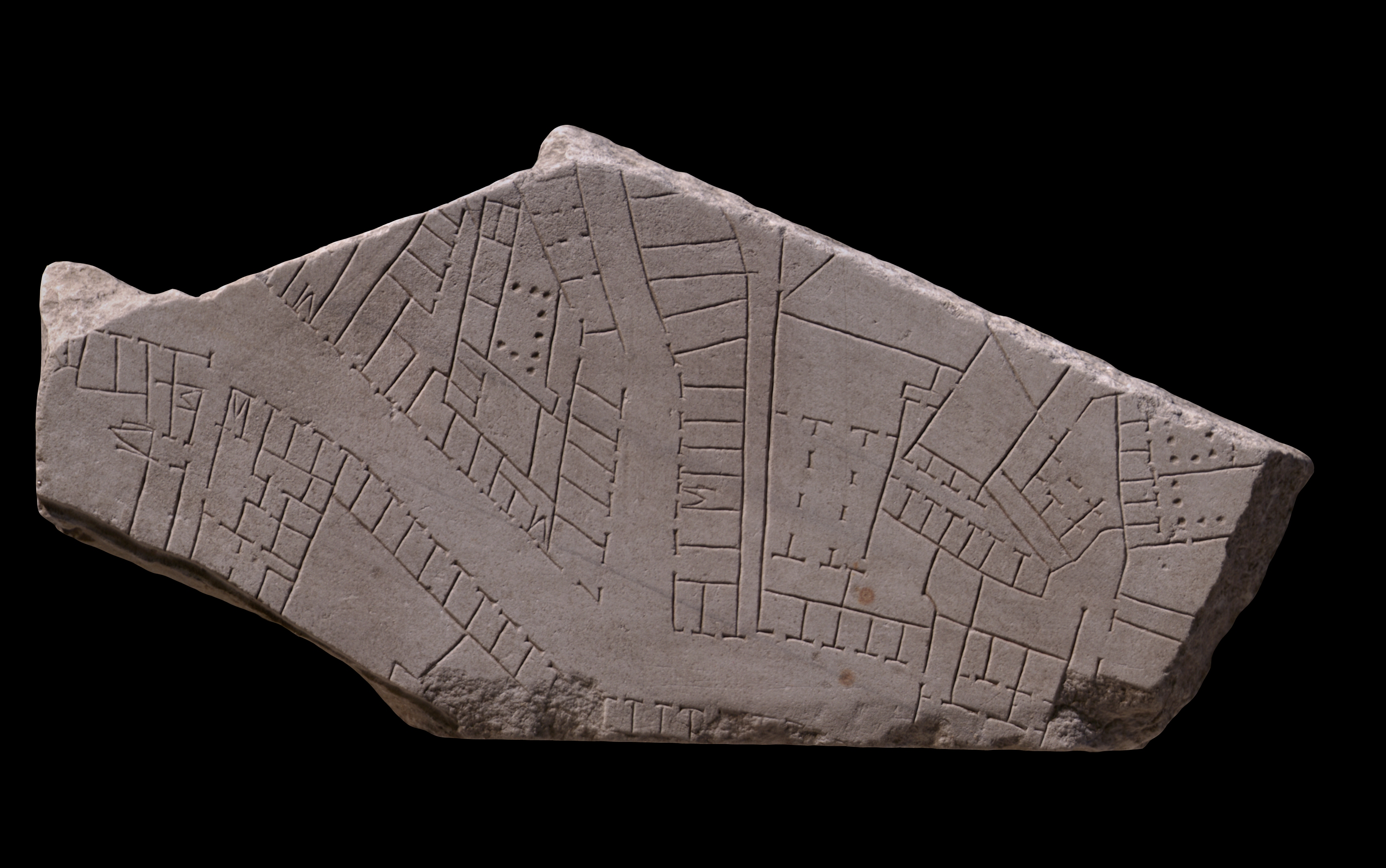
| Description This large fragment occupied most of the corner of a slab. On the bottom edge, a rectangular area has been chiseled away to accomodate the clamp from the adjoining slab. Only frs. 1a, 1b-e, 28c,
31dd, 138c, 329, 338, and 604 display a similar mark (generally on the bottom edge of the slab?). Two intersecting streets, both lined with tabernae, effectively divide the architecture on the fragment into three groups. At the bottom left corner, two large, open spaces are framed by rooms and tabernae and are separated by a narrow alley. Five internal staircases are visible in this group. In the upper left corner, a strangely trapezoidal architectural cluster is defined by the two shop-lined streets. The most interesting feature within this group is a porticoed space next to to a row of interconnecting rooms. At the right end of the fragment is a confusing mix of shops, plain and colonnaded courtyards, alleys, arcades, corridors(?), and apartments in a variety of triangular, trapezoidal, and rhomboidal shapes. Several spaces appear to be inaccessible; no doorways or other means of access are marked. These may be carvers' errors, or perhaps these spaces lay on a steeper slope and were reached from the storey above or below. The feature that seems to block the wide street in the bottom right corner might simply be a portico that covered a section of the street but did not block it (suggestion by C. Cecamore).
Identification: Clivus Suburanus The wide street that traverses the fragment from right to left (west to east) has been identified as the clivus Suburanus, a major street that ran from the Forum and the Argiletum through the Subura neighborhood, past the front of the Porticus Liviae, to the Esquiline Gate in the republican walls. Other sections of the street are visible on frs. 10Aab, 11a and 11c. Its probable route can be traced in several streets surviving in the modern topography of Rome: the Via di S. Vito, the Via di S. Martino, the Via in Selci, and the Via della Madonna dei Monti. (Note that newer, wider, and straighter streets--the Via dello Statuto, the Via Giovanni Lanza, and the Via Cavour--have largely bypassed this narrow and somewhat winding route.) The clivus Suburanus exited the Forum just west of the Basilica Aemilia and entered the Argiletum quarter through the Forum Transitorium of Nerva; this stretch of the street was called the Argiletum and was lined with the shops of artisans like sandal makers and book sellers (LTUR I, p. 287). Scholars believe that farther east, the street had a less commercial character, but this fragment shows a great many streetfront shops. E. Rodríguez-Almeida has suggested that the clivus Suburanus and the Subura effectively ended at the lacus Orphei in fr. 11a and that the remaining section of the street from this point to the Esquiline Gate was called something else, e.g. the vicus portae Esquilinae (Rodríguez-Almeida 1975-76, p. 278). This is refuted persuasively by K. Welch who points out that this name is not corroborated by literary evidence and that CIL 531, which places a Jewish synagogue near the Esquiline Gate, confirms that this area was still part of the Subura (LTUR IV, p. 379).
Identification: Subura This fragment represents a large section on the Oppian Hill of the residential and commercial district called the Subura. Archaeological and epigraphical evidence, in conjunction with the names of Medieval churches and quotes from Martial, locate the approximate boundaries of the Subura neighborhood. It began near the Argiletum and the Roman forum, and from there stretched, at least in imperial times, northward up the valley between the Quirinal and Viminal Hills and eastward between the Oppian and Cispian Hills, where it probably reached as far as the Esquiline Gate (LTUR IV, p. 379). An inscription (CIL 6.9526) indicates that in the imperial period the area was divided into two sections: the Subura maior and the Subura minor. The greater Subura has been identified with the largely commercial area near the Forum Romanum, between the Viminal and the Oppian Hills, and the lesser Subura with the upper section between the Cispian and Oppian Hills where the major thoroughfare of the Subura, the clivus Suburanus, ascended towards the Esquiline Gate (LTUR IV, p. 380).
Roman poets like Martial and Juvenal described the Subura as a sordid commercial area, riddled with violence, brothels, and collapsing buildings. In reality, it was probably not different from any other neighborhood in Rome where commercial activity intermingled with the religious and political life in the great public monuments and smaller local shrines and meeting halls of the local collegia, and where the large domus of the rich stood next to the decrepit apartment buildings that housed the poor. An abundance of evidence demonstrates that even in imperial times the Subura housed senators (probably on the upper slopes) as well as sandal makers, blacksmiths, and cloth sellers. Commercial activity was probably concentrated all along the clivus Suburanus. The many epigraphic references to the synagogue in the Subura, probably located in the Subura minor near the Esquiline Gate, suggest it was the center for the largest Jewish congregation in Rome (LTUR IV, pp. 382-383).
The colonnaded court with the suite of linked rooms at upper left has been identified as a bath complex, balnea (Reynolds 1996, fig. 3.41). The palaestra allowed for exercise, while the interconnected rooms would have followed the standard sequence from cold to hot bathing, i.e. frigidarium, tepidarium and caldarium. The bath's furnaces will have been located at the hot end, perhaps off the top edge of this fragment. The apodyterium was probably located at the lower end of this sequence of rooms, near the entrance to the baths from the street. The building located immediately behind the bath has a narrow entrance and a series of small rooms. It might represent an apartment complex or perhaps one of the many brothels for which the Subura was famous. On the right side of the fragment, the multiple orientations of buildings and the lack of clear entrances or access to several of the spaces may indicate that these features lie on sloping terrain that includes several changes of level. A variety of building types are represented, perhaps including stables, workshops and other commercial installations. The lines that apparently bar access to the double row of tabernae may in fact represent steps on the hillside leading to a street of specialized shops (suggestion by David West Reynolds). Alternatively, the comparatively restricted access to the rooms in this area may indicate that these are primarily residential spaces.
Significance This fragment provides detailed information about the urban fabric depicted on much of the Plan. No monumental buildings are represented here; 10g instead provides a view of the less well known residential and commercial spaces of ancient Rome. It may also teach us something about the way the survey of the city worked. Between the two streets at the upper left, the rooms and spaces are not rectangular as is typical on the rest of the plan. This may represent a skewing due to the surveyors' difficulty in matching up information from two different survey areas (PM 1960, p. 69, n. 3; Reynolds 1996, pp. 98-99). |
