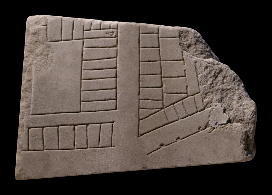
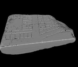
| Description The fragment formed part of the corner of a slab. One clamp hole is visible along top edge. The straight bottom edge is a modern cut (see history of fragment). A vertical street divides the architecture into two sections. Top left, a large courtyard is surrounded along the right and top edges by rows of tabernae. Although no openings are shown, the individual shops would have had access to the street (or to the courtyard). A staircase at top center may indicate that these rooms were above ground level and were entered from below, hence the lack of openings. Below lies a single row of tabernae, parallel to the courtyard building above. These shops also do not have any visible openings. In the right side of the fragment, the lower left corner of a trapezoidal or triangular building is visible. It is flanked on the left and along the bottom by non-accessible tabernae. An inner row of shops or rooms, facing inwards, lines the left side. Parallel to the bottom row of tabernae on the right runs a straight line with small circles added at regular intervals.
Identification: SW section of the campus Martius In 1980, E. Rodríguez-Almeida located this fragment to the bottom left corner of slab IV-7, right next to slab IV-6 where frs. 37f , gi, and h make up the bottom right corner (AG 1980, pp. 136-139, fig. 41). The clamp hole in the left side of this fragment matches precisely the clamp hole in the brick wall of the aula in the proposed location; cuttings along its left side match clamp holes in the right side of slab IV-6; the horizontal street in this fragment aligns with the one in fr. 37gi; the left curving street in 37gi follows the outline of the river as indicated in this fragment (see AG 1980, fig. 41); finally, the depth, width, and style (ductus) of the engraved lines in this fragment match those of the fragments in slab IV-6, suggesting they were engraved by the same person (AG 1980, p. 137).
In 1983, the author confirmed this earlier identification and suggested that the fragment be renamed 37Am (Rodríguez-Almeida 1983a, p. 90). The location on the Marble Plan identified the architecture in this fragment as belonging to a section of the campus Martius along the Tiber, between Via delle Zoccolette and lungotevere dei Vailati (see Rodríguez-Almeida 1983a, fig. 3). The architecture seems to have been a mixture of residential and commercial structures.
Identification: Tiber River The blank section that was sawed off the fragment in the 18th century represented a section of the Tiber. Italy's third longest river, the Tiber winds its way through Rome about 25 km before it drains into the Tyrrhenian Sea. In antiquity, only Tiber Island and perhaps eight bridges interrupted its 5.6 km long stretch between the Aurelian Walls (see LTUR V, fig. 46). For the Romans, the Tiberis (other appellations were Albula, Thybris and Tiberinus) was a provider of both bounty and frustration. It was the vital trade route between the city and the outside world; fishing in its waters provided food; and until the construction of Rome's aqueducts it was the major source of drinking water. However, the Romans struggled endlessly to keep the waterway navigable and to control the violent and frequent floods. Commercial buildings such as the horrea seen here were constructed along its banks as early as the 2nd c. BCE., and later the villas, horti, and mausolea of the upper class vied for space along the river with the apartments and cemetaries of the less fortunate (LTUR V, pp. 69-73). Remains of these buildings, especially of the commercial structures and the residences of the poorer classes, were largely destroyed when retaining walls were constructed on both sides of the river at the end of the 19th c. (It was during the construction of the Tiber embankment along the Via Giulia in 1888 or 1898 that hundreds of FUR fragments were discovered.) The appearance of these non-monumental structures on the Marble Plan is therefore of great importance.
Despite its important role in Rome's economy and social and political history, the Tiber is not outlined on the Marble Plan. As in this fragment, it appears simply as a blank space whose shape is discernible only through the construction that frames it on both sides. Although color was used to highlight certain buildings and streets on the Plan, there is so far no evidence to show that the river was emphasized in any way (except a possible label, Tiberis, inscribed in fr. 200b[Rodríguez-Almeida 1992, pp. 59-60]).
Significance This fragment reveals the curious convention of the Marble Plan of not outlining the edges of the Tiber. The sawed-off piece also demonstrates the disregard with which blank areas of the Plan were considered in the 18th c. During the attempted reconstruction of the FUR in 1742, the curators of the Capitoline Museums sawed off blank segments of several pieces in order to fit them into wooden frames (PM 1960, p. 27). This is especially unfortunate today, as we now have the possibility of joining fragment edges via computer algorithms. This piece is a valuable example of unidentified fragments of the Plan, as it represents the kind of lesser-known residential and commercial structures that existed along the Tiber, a good distance from the well-documented monumental architecture in the center of the city.
|
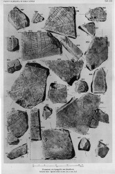
| Like the majority of FUR fragments, this piece was discovered in 1562 in a garden behind the Church of Saints Cosmas and Damian. From here, it was transferred to the Palazzo Farnese and stored there. It was not among the fragments that were reproduced in the Renaissance drawings that are now kept in the Vatican, but Giovanni Pietro Bellori included it in his 1673 publication. In 1742, the fragment was moved to the Capitoline Museums and exhibited with some of the other known fragments in wooden frames along the main staircase. It was at this time that the blank section of the fragment was cut off to fit it into the frames (PM 1960, pp. 27, 152). Since then, it has been stored with the other FUR fragments in various places: the storerooms of the Capitoline Museums (1903-1924), the Antiquarium Comunale (1924-1939), the Capitoline Museums again (1939-1955), the Palazzo Braschi (1955-1998), and since 1998 in the Museo della Civiltà Romana in EUR under the auspices of the Sovraintendenza ai Beni Culturali del Comune di Roma. (This fragments history corresponds to Iter E as summarized in PM 1960, p. 56.)
Text by Tina Najbjerg
|