ID AND LOCATION
| Stanford #
| 37gi |
| AG1980 #
| 37gi |
| PM1960 #
| 252 a c |
| Slab #
| IV-6 |
| Adjoins
| 37Am 37h |
CONDITION
| Located
| true |
| Incised
| true |
| Surviving
| true |
| Subfragments
| 2 |
| Plaster Parts
| 0 |
| Back Surface
| smooth |
| Slab Edges
| 2 |
| Clamp Holes
| 1 |
| Tassello
| no |
TECHNICAL INFO
|
|
|
|
|
|
|
|
|
|
|
| ANALYSIS
|
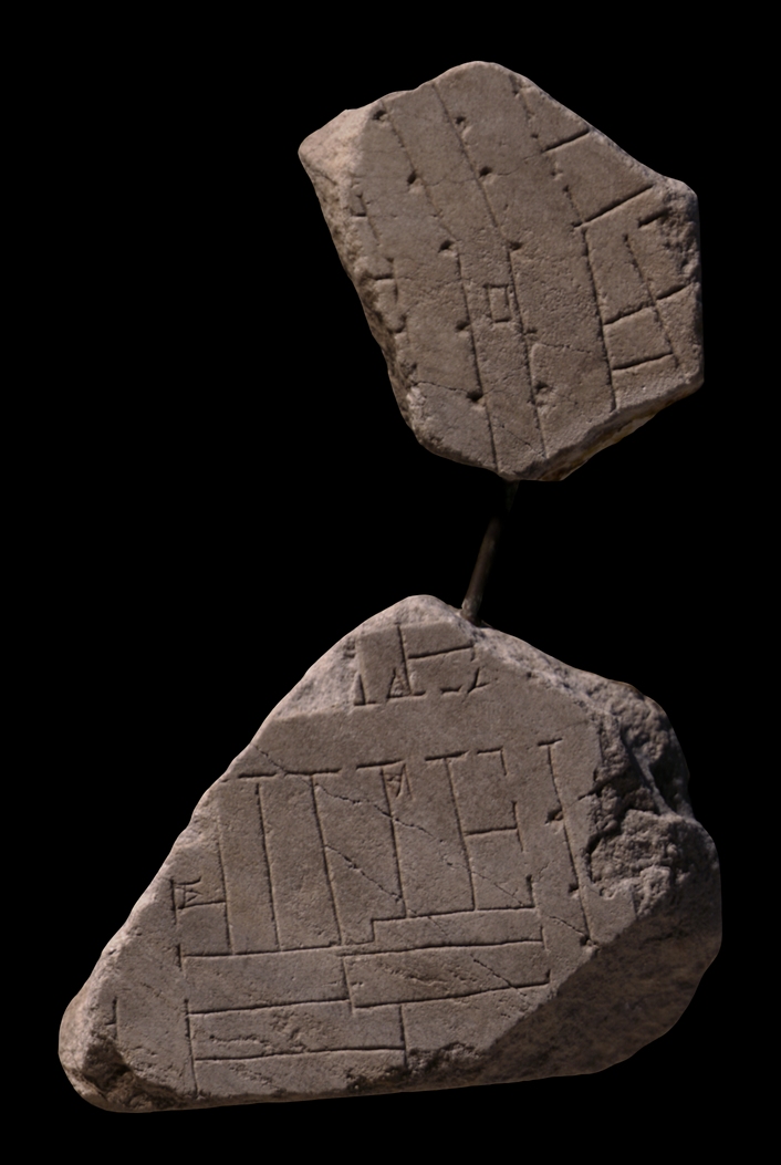
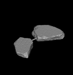
| Description The two fragments do not join, but are bolted together by a metal bar. The small fragment 37h is the link that joins the two (see PM 1960, pl. 43). The upper fragment, 37g, was part of a vertical slab edge; the lower piece, 37i, is a section of a horizontal slab edge. A clamp hole is visible in the right side of 37i. A vertical street traverses the center of fr. g and is visible in the right side of fr. i. Two parallel lines run along the entire stretch of the vertical street; these are flanked at regular intervals by simple dots that probably denote columns. Note that these are incorrectly drawn as outlined squares in AG 1980, fig. 39. In the center of fr. g, the vertical street makes a slight turn towards the left, and right where it breaks, a rectangle (a fountain?) is situated in the middle of the street. In fr. i, the vertical street is crossed by a horizontal street. Tabernae line the vertical street along its entire course. Fr. i shows that these tabernae were part of city blocks (insulae) that consisted of rectilinear rooms. The rooms of the insula that occupies most of fr. g are long and narrow; one even spans the entire block. Two staircases are visible in this insula, suggesting it was a multi-storeyed complex with what was probably apartments on the upper storeys above the shops. The corner of another insula is visible at the top of fr. i, across the horizontal street that crosses the fragment; it was also a multi-storeyed building. The large block in fr. i was flanked on the left by another vertical street. Behind it, a few lines from the next insula over are just visible in the left edge of the fragment.
Identification The qualities of slab IV-6 are determined by several securely positioned fragments, for example those that depict the Republican temples in the Largo Argentina. These qualities (the thickness and color of the marble, the ductus of the engraving, the surface deterioration, the veining direction, and sawing irregularities on the back [zigrinatura]) allowed E. Rodríguez-Almeida to place fragment group 37ghi in the lower right corner of slab IV-6 (Rodríguez-Almeida 1978-80a, pp. 95-96, fig. 3). The near join with and similar architecture of these fragments to fr. 37f
(depicting a section of the vicus Stabularius) which Rodríguez-Almeida had earlier located near the lower right corner of slab IV-6, solidified his location of fr. 37ghi. In 1983, Rodríguez-Almeida further cemented their location when he discovered that the clamp hole in fr. 37i fit a corresponding clamp hole on the wall of the aula. At the same time, he located fr. 602
in the lower left corner of the next slab over, slab IV-7; the architecture of this new fragment matched and joined exactly that of these fragments (Rodríguez-Almeida 1983a, pp. 87-90, fig. 1). This location identified the architecture depicted in frs. 39ghi as a section of the campus Martius, between the vicus Stabularius and the Tiber river (see AG 1980, fig. 41). The vertical street in these fragments was identified as the vicus Aesculati, an ancient street that followed the bend of the river, as seen in fr. 37g, and the parallel lines along its middle as a double colonnade (Rodríguez-Almeida 1978-80, p. 101; 1983a, p. 90, fig. 1). A different thesis was presented in 1977 by F. Coarelli, who suggested that the double lines represent the Euripus that drained the stagnum Agrippae (Coarelli 1977, pp. 834-837). Coarelli interpreted the dots along the lines as trees and the rectangle between them as a statue base. Rodríguez-Almeida's positioning of this fragment in slab IV-6 has since rendered Coarelli's identification impossible, but the notion that the double lines depict a canal, not a double colonnade, is supported by C. Bruun, who, however, identifies the dots along the lines as border stones and the large rectangle as a stepping stone for crossing the channel (C. Bruun, The water supply of Ancient Rome [Helsinki 1991] pp. 121-123). Bruun's thesis is convincing except on one point: he mistakes the dots that accompany the double lines as outlined squares (probably using Rodríguez-Almeida's incorrect representation of these in AG 1980, fig. 39, or Rodríguez-Almeida 1983a, p. 89), a feature that is highly unusual on the Plan (a rare example is 39f). The double lines down the Via Aesculati are accompanied by dots and they probably represent colonnades (see for example the colonnade that follows the edge of the Tiber in the adjoining fr. 37Am). Rodríguez-Almeida and Coarelli/Bruun's theses need not be mutually exclusive, however; the double lines here may depict an open water channel flanked on either side by colonnades and thus represent one of the many euripi that existed in the campus Martius (Pliny, NH 36.123 [reference from Bruun, p. 121]). The small, rectangular feature within the double set of lines has also been identified as a neighborhood shrine (Sartorio 1988, p. 32).
Significance The architecture and marble characteristics of these fragments allowed Rodríguez-Almeida to locate them in slab IV-6, thus greatly enhancing our knowledge of this non-monumental area of the campus Martius.
|
|
| HISTORY OF FRAGMENT |
| Like the majority of FUR fragments, these two pieces were discovered in 1562 in a garden behind the Church of Saints Cosmas and Damian. From here, they were transferred to the Palazzo Farnese and stored there. Fr. 37g was later used as building material in a 17th c. Farnese construction, the Secret Garden. It was rediscovered in 1888 or 1898 when the walls of the garden near the Via Giulia were demolished and until 1903 it was kept in the storerooms of the Commissione Archeologica. Fr. 37i was not among the fragments that were reproduced in the Renaissance drawings that are now kept in the Vatican, but Giovanni Pietro Bellori included it in his 1673 publication. In 1742, the fragment was moved to the Capitoline Museums and exhibited with some of the other known fragments in wooden frames along the main staircase. Between 1903 and 1924, it was kept in storage in the Capitoline Museums. Since 1924, the two fragments have been stored together with other known FUR fragments in the Antiquarium Comunale (1924-1939), the Capitoline Museums again (1939-1955), the Palazzo Braschi (1955-1998), and since 1998 in the Museo della Civiltà Romana in EUR under the auspices of the Sovraintendenza ai Beni Culturali del Comune di Roma (The history of frs. 37g and 37i corresponds to Iter E'' and E' as summarized in PM 1960, p. 56). N.B. PM 1960 does not indicate the history of fr. 37g between 1903 and 1924.
Text by Tina Najbjerg
|
|
| KEYWORDS
|
| colonnade, tabernae, street, apartments, stairs, aqueduct, water channel?, euripus?, insula, shrine? |
|