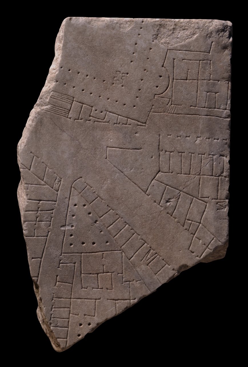
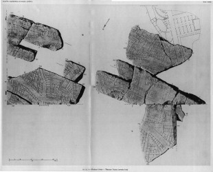
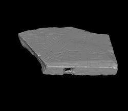
| Description The large piece constituted the corner of a slab. A wide street traverses the fragment from left center to right bottom. A smaller, horizontal street breaks off from this wider road at the top of the fragment. Top left, a wide staircase provides access to a large, double-porticoed structure of which only the bottom right corner is visible here. Three exedrae of various shapes and sizes are situated in the rear walls of the porticoed building. A strange, four-lobed feature is located where the two rows of colonnades meet. A few shops back onto the front of the large building and face the horizontal street. To the right of the small, apsed exedra, an opening leads from the porticoed structure to a narrow passageway that seems to surround the building. The opening also leads to two sets of stairs next to the horizontal street. NB. Only one set of stairs is included in AG 1980, pl. 9. A group of rooms (small apartments?) are tucked away between the large exedra and the street - these rooms are accessed from the two narrow passageways. The triangular section on the right, between the horizontal and the major diagonal street, consists of different types of tabernae: at top, a row of plain shops is fronted by an arcade; below, a row of plain shops faces the diagonal street; and below them there seems to be a row of tabernae with back rooms. The area between these may have been open. The tip of the triangular area is partially enclosed by a wall; it was probably open to the sky. Below the diagonal thoroughfare, the architecture is divided in two by a vertical street. The section to the right is bordered on the left mainly by shops that face the vertical street, and on the right by tabernae that face the diagonal street. A staircase leads to a second storey above the shops on the right. A triangular, colonnaded courtyard is situated in the tip of this section. Although no visible openings lead to it, it was probably accessible from the tabernae on the right. A narrow entrance in the left side of this section, between the triangular portico and the row of shops that faces the vertical street, leads to a structure that seems to occupy most of the interior of this insula. Having made first a right, then a left turn, the narrow entryway gives access to two rooms on the left and to a smaller hall that leads to two larger, connecting rooms. On the right, the entryway opens onto a large, colonnaded courtyard with a large room in the upper left corner. A small opening in the right wall of the peristyle gives access to another triangular yard with a series of rooms tucked away in the back (only visible in fr. 11b). Tabernae with back rooms and plain shops line the partially visible section across the vertical street and along the diagonal street.
Identification: Subura This fragment represents a section of the residential and commercial district called the Subura. Archaeological and epigraphical evidence, in conjunction with the names of Medieval churches and quotes from Martial, locate the approximate boundaries of the Subura neighborhood. It began near the Argiletum and the Roman forum, and from there stretched, at least in imperial times, northward up the valley between the Quirinal and Viminal Hills and eastward between the Oppian and Cispian Hills, where it probably reached as far as the Esquiline Gate (LTUR IV, p. 379). An inscription (CIL 6.9526) indicates that in the imperial period the area was divided into two sections: the Subura maior and the Subura minor. The greater Subura has been identified with the largely commercial area near the Forum Romanum, between the Viminal and the Oppian Hills, and the lesser Subura with the upper section between the Cispian and Oppian Hills where the major thoroughfare of the Subura, the clivus Suburanus, ascended towards the Esquiline Gate (LTUR IV, p. 380).
Roman poets like Martial and Juvenal described the Subura as a sordid commercial area, riddled with violence, brothels, and collapsing buildings. In reality, it was probably not different from any other neighborhood in Rome where commercial activity intermingled with the religious and political life in the great public monuments and smaller local shrines and scholae, and where the large domus of the rich stood next to the decrepit apartment buildings that housed the poor. An abundance of evidence demonstrates that even in imperial times the Subura housed senators (probably on the upper slopes) as well as sandal makers, blacksmiths, and cloth sellers (LTUR IV, pp. 382-383). The building that occupies most of the triangular insula in the bottom of this fragment may have been a large domus (PM 1960, p. 69).
Identification: Clivus Suburanus The diagonal street that traverses this fragment has been identified as the clivus Suburanus, a major thoroughfare that ran from the Forum and the Argiletum through the Subura neighborhood to the Esquiline Gate in the Republican walls (PM 1960, p. 70). Other sections of this street are visible on frs. 10Aab,
10g, and
11c. The clivus Suburanus exited the Forum just west of the Basilica Aemilia and entered the Argiletum quarter through the Forum Transitorium of Nerva; this stretch of the street was called the Argiletum and was lined with the shops of artisans like sandal makers and book sellers (LTUR I, p. 287). Scholars believe that farther east, the street had a less commercial character, but frs. 10g and 10Aab show that it was lined with shops along its entire course. Its probable route can be traced in several streets surviving in the modern topography of Rome: the Via di S. Vito, the Via di S. Martino, the Via in Selci, and the Via della Madonna dei Monti. (Note that newer, wider, and straighter streets--the Via dello Statuto, the Via Giovanni Lanza, and the Via Cavour--have largely bypassed this narrow and somewhat winding route.)
E. Rodríguez-Almeida identified the three circles in fr. 11c as the lacus Orphei. Since the 5th Augustan region is known to have begun at the lacus Orphei, Rodríguez-Almeida has proposed that the last stretch of the clivus Suburanus, between the lacus Orphei and the Esquiline Gate, was not part of the Subura and that it therefore must have been called something else, perhaps vicus portae Esquilinae (Rodríguez-Almeida 1975-76, pp. 276-278). K. Welch has counterargued that this name is not corroborated by literary evidence and that CIL 531 confirms that the area near the Esquiline Gate was still part of the Subura (LTUR IV, p. 379).
Identification: Porticus Liviae The large, porticoed structure partially visible in the upper left corner of this fragment is the porticus Liviae - clearly identified by an inscription in fr. 10opqr. The S end of the building is depicted in fr. 10lm. Built by Augustus in the name of his wife Livia on the site of a luxurious domus which he had inherited from Vedius Pollio (Ovid, Fasti 6.637-648; Suetonius, Augustus 29.4; Cassius Dio 54.23.1-6, 55.8.2), the building was formally dedicated in January, 7 BCE, by Tiberius and his mother Livia (LTUR IV, p. 127). Explicitly dedicated to marital harmony, it was by all accounts magnificent, with a garden and a collection of paintings. The Marble Plan provides irreplaceable information about the exact location and design of this now-lost building. It was situated at the edge of the Oppian Hill, with its northern, main entrance facing the clivus Suburanus (as seen in this fragment), and its rear backing onto the vicus Sabuci (see fr. 10lm). The building consisted of a gargantuan rectangle of about 120 x 70 m., with a large internal open space surrounded on all four sides by a double colonnade. The single vine stock that covered all of the walkways of the porticus Liviae, according to Pliny, HN 14.11 (Richardson 1992, p. 314), perhaps spread along these colonnades. Behind the double colonnades, exedrae of various shapes and sizes punctuated the back walls of the building. All exedrae were fronted by columns, giving the effect of a triple colonnade. The central exedra along the W wall was set farther N than its counterpart on the opposite wall; it was also deeper and wider, perhaps because it had a different role. The square, crenellated features in each corner of the open courtyard, just inside the double colonnades, are perhaps fountains (LTUR IV, p. 127) or small structures with statue niches in each face. The rectangular feature at the center of the courtyard has been interpreted as a monumental fountain on a podium (PM 1960, p. 69; Richardson 1992, p. 314) or an altar or small temple to Concordia, the goddess to whom the complex was dedicated (see references in LTUR IV, p. 128). The main access to the building was from the clivus Suburanus (the modern Via in Selci) through a monumental entrance with a central staircase in two flights, visible in this fragment. Small, extremely narrow openings are also seen between the two exedrae in the E wall, and in the W wall just north of the semi-circular niche in this fragment. Matching openings may have existed in the two opposite corners (see reconstruction in LTUR IV, fig. 46). The stairs in the N and the W walls suggest that a platform had to be constructed as a level foundation for the building on the sloping hill side. A few remains of the floor of the central courtyard have been excavated, as have even deeper remnants of a floor from Pollio's residence, which was razed to the ground to make way for the public porticus (LTUR IV, p. 128). The building seems to have been in use until the 4th and perhaps even the 5th c. In the 6th c., it became a graveyard -an interesting testimony to the decline of this formerly so busy area of Rome (LTUR IV, pp. 128-129).
Significance This fragment, with its mixture of shops, a large, single-family residence, and an enormous public porticus that would have served a multitude of religious and social functions, supports the thesis that the Subura was not merely a commercial area. |